Vietnam developed the North Dau navigation system receiver
Hanoi University of Science and Technology successfully developed the receiver operating with China's North Pole Navigation System.
Bac Dau is compatible with the US GPS navigation system, European Galileo system and Glonass of Russia. Bac Dau provides free civil navigation services with a range of 10m accuracy, and military service with accuracy up to 10cm. The birth of Bac Dau positioning system provides more options for location services for users worldwide.
With the aim of self-researching, developing and mastering the technology of manufacturing transceiver systems operating with multi-global satellite systems (multi-GNSS), the research group of the International Center for Development Research Satellite positioning technology (NAVIS), Hanoi University of Technology has developed the North Dau receiver as soon as the system starts to provide services in December 2012.
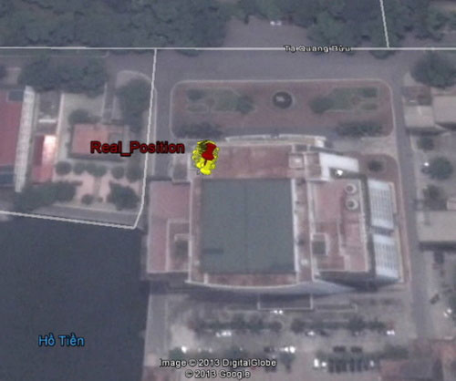
The positioning results use the Bac Dau system (yellow dots), and the actual position of the antenna (red dot), on the roof of the building Ta Quang Buu Library, Hanoi University of Science and Technology.(Photo: NAVIS)
The North American receiver developed by NAVIS is operating stably. Truong Minh Duc, head of NAVIS design team, said: 'Apart from China, the world has not yet disseminated North Dau trade receivers. Therefore, the successful development of Bac Dau collection is an important achievement in the field of satellite navigation in Vietnam ".
The testing process of Bac Dau collection shows that, for users in the Asia-Pacific region, including Vietnam, the North Dau navigation system is capable of providing location services with availability. High screen, reduce the complexity of positioning calculations in the receiver. These strengths are due to the addition of the medium-range Earth Orbital (MEO) as other satellite navigation systems, Bac Dau also uses geostationary orbits (GEO), and Earth synchronous orbits. inclined (IGSO) helps increase the ability of the receiver to 'see' satellites.
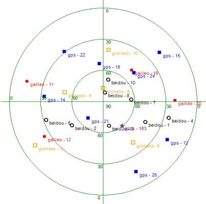
Location of 26 positioning satellites of all global positioning systems, in the sky of Hanoi at the time of operation, provided by NAVISOFT: GPS (8 bold square dots), Gal (Galileo, 4 Dark dot), GLO (GLONASS, 5 light square dots), BDS (Big Dipper, 8 light dots), Qzss (QZSS, 1 star point).(Photo: NAVIS)
Bac Dau collection also added an important component in NAVISOFT collection system which is being developed by NAVIS Center. NAVISOFT is capable of operating with all global positioning satellite systems (GPS, GLONASS, Galileo and Bac Dau), as well as being able to receive information rectified by Japan's QZSS positioning satellite system Version provided.
In particular, in addition to operating each individual system (stand-alone), NAVISOFT also integrates the ability to simultaneously coordinate positioning signals coming from these systems in mixed positioning solutions. This is an advanced and advanced feature that enhances the accuracy, availability, continuity and reliability of the positioning solution.
- Chinese navigation system works
- The Chinese navigation system is recognized by international organizations
- China upgraded the North Dau system
- The Chinese positioning system approaches the ASEAN market
- Soon there is a navigation system for the spacecraft
- Russia shares GLONASS navigation system information with Vietnam
- Brazil receives Russian satellite navigation system
- China successfully launched the 10th North Dau satellite
- China takes two satellites to lead North Road 3 into space
- The EU Galileo navigation system receives more new satellites
- Develop a virtual visual positioning system for pilots
- Home navigation system for the visually impaired
 Van Allen's belt and evidence that the Apollo 11 mission to the Moon was myth
 The levels of civilization in the universe (Kardashev scale)
 Today Mars, the sun and the Earth are aligned
 The Amazon owner announced a secret plan to build a space base for thousands of people