'Wild boar' staggered, predicting a rampage
The storm " Wild boar " (Cimaron) has hurt the meteorological forecast centers of Vietnam and Vietnam. They predicted storm moved in panic. On the morning of October 31, the meteorological authorities predicted that the storm would enter Central Vietnam, but in the afternoon, the storm forecast will enter the east of Lei Chau Island (China). By November 1, the morning forecasted that the storm would change direction to Hainan Island, and in the evening, it was forecasted to land in Guangdong. Why is that?
Some experts forecast the weather of countries around the world to explain why there is a disorder in the forecast.
- Mr. Jim Andrews, international meteorological forecaster for weather forecasting Accuweather (USA):
Cimaron storm had to find its way in a very weak situation, the pressure areas (and the wind) were too complicated, then the difference between the numerical prediction models (without small errors) would lead to A big difference in forecasting the path of a storm. When predictive models bring too different results (including running a model over and over), the forecaster must be the decision maker.
It was absolutely not surprising that Cimaron stormed like that. Certainly, the forecast of the direction of the storm was too different. And it's no surprise to me that these forecasts can change dramatically when comparing the previous and the next. High pressure center is the factor that helps guide the path until the storm changes.
In the case of Cimaron, there is high pressure in the middle of China and the weak activity of the upper northeast monsoon and Cimaron. Therefore, the high pressure was controlled and the direction of Cimaron only moved in the area near the south coast of China or moved slowly in the southwest direction (can be directed to Vietnam).
It was too early to talk about Cimaron's final destination. It seems to be weakening and will continue like that. However, there is reason to believe it will melt on the East Sea and not on land as a storm.
* Mr. Lee Woo Jin, senior forecaster of Korea Meteorological Agency:
In fact, it was not surprising that so many storms had been very chaotic ever since the school was weak. On the morning of October 31, Cimaron's guide field became much weaker when approaching the upper floor with subtropical high pressure in the northwest.
Since then, conventional forecasting models have experienced big deviations in forecasting the direction. Obviously the lead field is already very weak, which is probably the biggest reason for forecasts to keep changing. In the next three days, the storm will almost never move, then if it has not melted, it will move in the southwest direction.
* Mr. CM Cheng, expert forecasting Hong Kong Meteorological Agency (China):
The direction of Cimaron is predicted by the numerical model (NWP). Currently storm forecasting depends very much on NWP. Before the afternoon of October 31 most NWPs thought that Cimaron would move westward across the East Sea and on the southwestern side of subtropical high pressure in the Western Pacific and would land in Vietnam.
But at the end of the day, some NWP models began to predict the upper high pressure area to start moving across China, linking and penetrating deep into Cimaron. And as a result, Cimaron's forecast changed rapidly from west to northwest and moved slowly to the north. This makes the forecast of many centers changed in this direction.
Forecast of US naval storm Cimaron in recent days:

The first is directed at Vietnam (1)
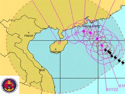
Later on Hainan Island (2)
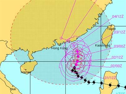
Then turn to Hong Kong (3)
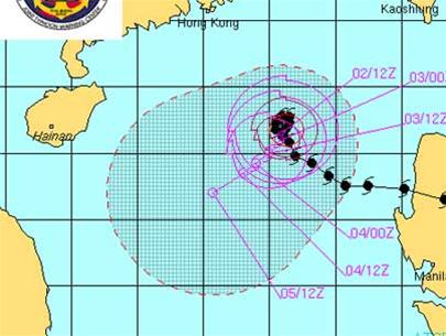
Come back to the evening and turn to Vietnam (4)
QUANG HIEU performed
- The 227kg wild boar monster was defeated
- US officials have a headache for wild boar
- The unknown things about wild boar
- The island was suddenly invaded by an army of wild boars
- Japan: Aging people, wild boar overgrown
- The jaguar is dreadful,
- Bloody deaths between dogs and wild pigs in Indonesia
- Video: Arena scene of pitbull dog death fighting bloody wild boar
- Raising wild boar
- The battle between wild boar and lion through photos
- Infected wild boar flooded Fukushima street
- Fukushima is flooded with radioactive wild boar
 Is the magnetic North Pole shift dangerous to humanity?
 Washington legalizes the recycling of human bodies into fertilizer
 Lightning stone - the mysterious guest
 Stunned by the mysterious sunset, strange appearance