Actively respond to hurricane Krosa
At 13:00 on October 30, the location of the center of the storm is about 16.8 degrees Vi Bac; 128.4 degrees Kinh Dong, about 670km from Lu-Dong Island (Philippines) to the East. The strongest wind is in the area near the center of strong storm level 9, level 10 (ie from 75 to 102 km per hour), level 12 and level 13 jerks.
>>>Emerging storms near the East Sea
It is forecasted that in the next 24 hours, the storm will move in the direction of West and Northwest Northwest, about 20 - 25km per hour and will continue to increase. By 13:00 on October 31, the location of the center of the storm was about 17.8 degrees Vi Bac; 123.2 degrees Kinh Dong, about 120km from Lu-Dong Island (Philippines) to the East. The strongest winds in the area near the storm center are strong at level 10, level 11 (ie from 89 to 117 km per hour), level 13 and level 14 jerks.
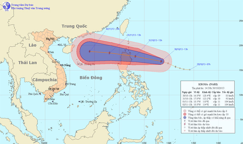
Photo of the path and location of hurricane Krosa
In the next 24 to 48 hours, the storm continues to move in the direction of West and West Northwest, about 20-25 km per hour. By 13:00 on November 1, the position of the center of the storm was about 18.5 degrees North latitude; 118.0 degrees east longitude, about 670 km east of Hoang Sa archipelago. The strongest wind in the area near the center of the storm is strong at level 10, level 11 (ie from 89 to 117 km per hour), jerky level 13, level 14.
In the next 48 to 72 hours, the storm moves mainly in the direction of West-West and West-Northwest every 15 to 20 km.
Due to the influence of storm circulation, from the night of October 31, the East Sea in the East Sea gradually increased to level 6, level 7, then increased to level 8, level 9, the area near the center of the storm passed through level 10, level 11, level 13, level 14. jolted sea.
- Typhoon Krosa is stronger and accelerates into the South China Sea
- Hurricane Krosa jerked level 13 into the South China Sea
- Storm No. 12 weakens into a tropical depression
- Typhoon Krosa is strong up to level 15, going straight to the Central
- Typhoon Krosa threatens the Central
- Storm No. 12 constantly changes direction
- Typhoon Krosa can cause heavy rain in the Central region
- A storm near the East Sea appears
- Hanoi plans to respond to super typhoon Mangkhut
- China hustled against storm Krosa
- On the evening of December 11, the 5th hurricane will land
- 'Vietnam needs to actively participate in combating climate change'
 Is the magnetic North Pole shift dangerous to humanity?
 Washington legalizes the recycling of human bodies into fertilizer
 Lightning stone - the mysterious guest
 Stunned by the mysterious sunset, strange appearance