A storm near the East Sea appears
Currently, a storm is operating in the Eastern Philippines and has an international name of KROSA.
At 07:00 on October 30, the location of the center of the storm is about 16.4 degrees Vi Bac; 129.8 Kinh Dong. The strongest wind is in the area near the center of strong storm level 9, level 10 (ie from 75 to 102 km per hour), level 12 and level 13 jerks.
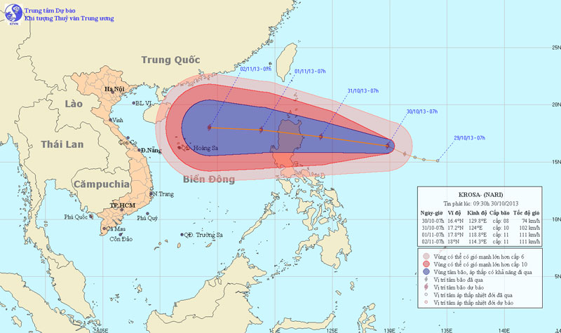
Photo of the path and location of hurricane Krosa
It is forecasted that in the next 24 hours, the storm will move in the direction of West and Northwest Northwest, about 25km per hour and further increase.By 07:00 on October 31, the location of the center of the storm was about 17.2 degrees Vi Bac;124.0 degrees Kinh Dong, about 180km from Lu-Dong Island (Philippines) to the East.The strongest wind in the area near the center of the storm is strong at level 10, level 11 (ie from 89 to 117 km per hour), jerky level 13, level 14.
In the next 24 to 48 hours, the storm continues to move mainly in the direction of West and Northwest Northwest, about 20 - 25km per hour.By 07:00 on November 1, the location of the center of the storm was about 17.8 degrees Vi Bac;118.8 degrees Kinh Dong, about 720km east of Hoang Sa archipelago to the Northeast.The strongest wind in the area near the center of the storm is strong at level 10, level 11 (ie from 89 to 117 km per hour), jerky level 13, level 14.
In the next 48 to 72 hours, the storm moved mainly in the West every hour, about 20 km away.
Due to the influence of storm circulation, from the night of October 31, the East Sea in the East Sea gradually increased to level 6, level 7, then increased to level 8, level 9, the area near the center of the storm passed through level 10, level 11, level 13, level 14. jolted sea.
- Storm No. 15 has not melted, near the East Sea, a new storm appears
- Tin storm on the East Sea (storm No. 7)
- Storm No. 12 weakens into a tropical depression
- Hurricane Kalmaegi moves at a very fast speed
- Tin storm on the East Sea: Typhoon Khanun
- Typhoon Kalmaegi directly affects the North
- Typhoon Kalmaegi has entered the South China Sea, the country has scattered rain
- Storm No. 10 leaves the East Sea, still heading towards Vietnam
- A new storm appeared on the east sea, storm Pakhar
- A strong storm of level 14 appeared in the South China Sea
- 19h tonight, the storm center is located on the waters of Quang Ninh - Hai Phong
- Depressing tropical depression in the East Sea
 Is the magnetic North Pole shift dangerous to humanity?
 Washington legalizes the recycling of human bodies into fertilizer
 Lightning stone - the mysterious guest
 Stunned by the mysterious sunset, strange appearance