News of tropical depression near the East Sea
At 1 hour on June 20, the position of the tropical depression center is about 19.5 degrees North latitude; 121.3 Kinh Dong, about 90 km from Lu - Dong Island (Philippines) to the North. The strongest wind in the area near the center of strong tropical depression at level 7 (ie from 50 to 61 km per hour), level 8, level 9.
It is forecasted that in the next 24 hours, the tropical depression will move in the direction between the Northwest and the Northwest Northwest, about 15 to 20 km per hour, and it is likely to become a storm. At 1 hour on June 21, the location of the center of the storm is about 21.1 degrees north latitude; 117.3 degrees Kinh Dong, about 380 km from Hong Kong (China) to the Southeast. The strongest winds in the area near the storm center are strong at level 8 (ie 62 to 74 km per hour), level 9 and level 10 jerks.
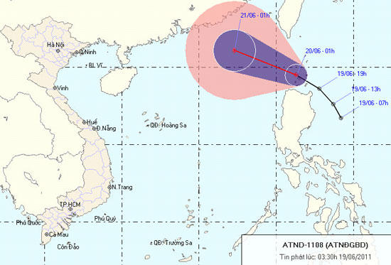
Due to the impact of tropical depressions, the East Sea in the East Sea has strong winds of level 6, after rising to level 7, the area near the storm center passes through level 8, level 9, level 10. The sea is strong. In addition, due to the effects associated with the operation of the southwest monsoon in the middle and south of the South China Sea (including the waters of the Spratly Islands), the sea off the Binh Thuan to Ca Mau provinces has strong winds. level 5, sometimes level 6, level 7, level 8, rough seas and showers and scattered thunderstorms. In a thunderstorm, there should be a tornado.
News broadcast at: 3:30
- Tropical depressions landed on the East Sea
- Tropical depression towards the East Sea
- News of tropical low pressure near shore
- Tropical depression Kajiki weakened in the East Sea
- Appears tropical depression near the East Sea
- News of nearshore tropical depressions and tropical depressions near the East Sea
- Appears tropical depression on the East Sea
- Hurricane 4 has just weakened and appeared a tropical depression heading into the East Sea
- Tropical depressions cause heavy rain and thunderstorms
- Depressing tropical depression in the East Sea
- News of tropical depressions in the East Sea
- Tropical depressions move quickly at sea, with the possibility of strong storms
 Is the magnetic North Pole shift dangerous to humanity?
 Washington legalizes the recycling of human bodies into fertilizer
 Lightning stone - the mysterious guest
 Stunned by the mysterious sunset, strange appearance