Ancient discovered 'volcanic map' carved into the rock
An elaborate 2,000-year-old volcanic map has been discovered carved into a large volcanic rock in Mexico.
Experts from the Mexican Institute of Anthropology and History (INAH) recently analyzed a mysterious rock located on a private land in Colima, Mexico.
The rock itself is also the result of a volcanic eruption covering more than 14km. The eruption happened thousands of years ago. The scientists determined that the rock is about 1.7m high, wider than 2 - 3m, thick from 0.6m - 1.7m.
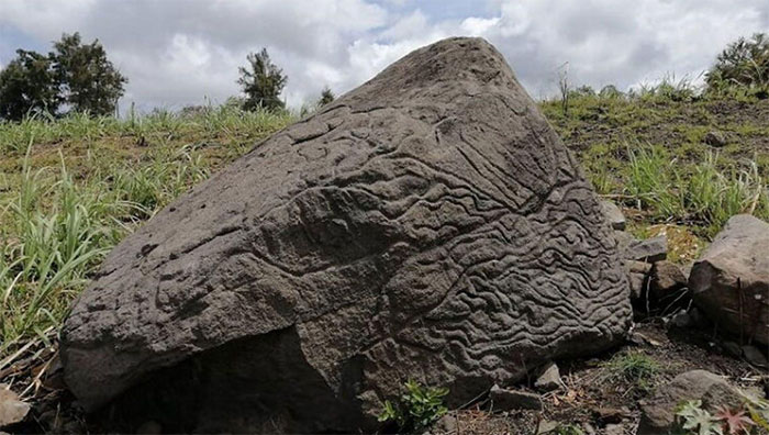
The rock with the mysterious volcanic map.
When archaeologists examined this ancient rock, they found a strange map carved into it. INAH explained that this map is used to manage the land in that area and also to transfer knowledge from generation to generation.
By studying the engraving techniques used on the stone, experts say the work could have taken place sometime between 200 BC and 200 AD.
According to INAH, various engraving techniques were used to describe the southern ridge of the volcano, created by characteristics such as rivers, currents and ravines. Meanwhile, the main surface with small niches is carved to represent the local community.
With this discovery, Mexico continues to reveal new aspects of its rich history. Earlier, according to INAH, archaeologists announced the discovery of a mysterious eighteenth-century shipwreck off the coast of Mexico.
- Petra: The ancient city in the heart of the rock
- Overwhelmed with volcanic eruptions
- Detecting ancient rocky beaches dating from 300-400 years in Mu Cang Chai
- The mysterious ancient rock in Africa makes archaeologists 'headache' unable to decode
- Discovered 2 ancient lakes under the surface of Mars
- Hundreds of remains reveal tragedy
- Discovered Buddha statues carved from extremely rare meteors
- Discovered an ancient character of 3,000 years resembling an airplane in Egypt
- Discover ancient stone ammunition warehouse at Ho Citadel's heritage
- Mexico discovered 5000 ancient paintings in the cave
- The 3300-year-old coffin carved his face
- Fans are excited to discover the ancient gods on Mars
 Discovered an ancient centipede fossil 99 million years old
 Discovered bat-like dinosaurs in China
 Discovered a 200-year-old bronze cannon of the coast
 Discover 305 million-year-old spider fossils