Big storms appear in Central America and the Caribbean
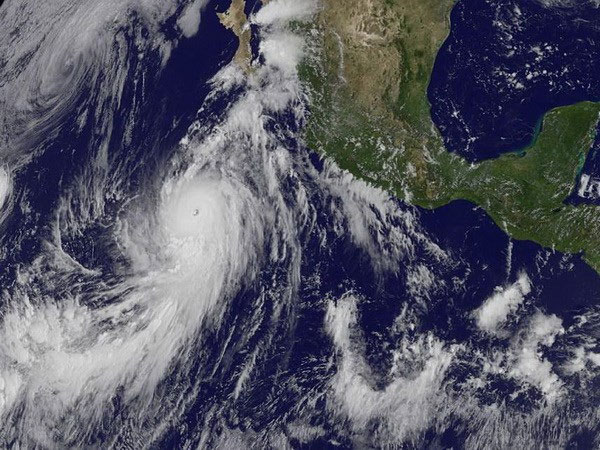
Hurricane Marie in the Pacific on August 24 has increased in intensity, becoming a Category 5 storm, threatening to cause heavy rain and big waves overflowing in many parts of Mexico.
According to the Miami-based National Hurricane Center (NHC) forecast, Hurricane Marie has a maximum continuous wind speed of 260km / hour.
The storm is still about 805 km south of Mexico's Baja California peninsula and is moving at 22.5 km / hour.
According to the warning, this storm may continue to increase in intensity in the next 1-2 days.

Images of Marie storm taken from satellites.(Source: NASA / AFP)
In some parts of Mexico's southwest coast, there was a big wave and this phenomenon is likely to spread to Baja California and the Gulf of California in the South as the storm continues to move to the Northwest.
Mexico's weather information said that on August 23, heavy rains landed in six Mexican states including Michoacan, Colima, Guerrero, Oaxaca, Jalisco and Nayarit, threatening to cause landslides and floods overflowing at the river.
The government recommends that people in these areas implement safety measures and track storm updates.
Meanwhile, in central Bahamas, tropical storm Cristobal is moving with winds of over 72km / h but is unlikely to become a major storm.
Information from the NHC said the storm is 300km east-east of Inagua Island, Cristobal storm is moving at 13 km / hour and is likely to continue to grow in the next three days.
However, the storm now moving east of Central Bahamas on August 25 will then head out to the Atlantic Ocean to the northeast before weakening and disappearing.
During the last two days, Typhoon Cristobal brought heavy rains into Central and Southeastern Bahamas, as well as part of Haiti and the Dominican Republic.
- Central America suffered from many natural disasters
- The cleaner the air, the more the number of storms increases
- Why are storms in Vietnam so good in Central Vietnam?
- The Caribbean region needs a solution to climate change
- The Caribbean region is vulnerable to climate and economic problems
- Cold air and circulation of storms cause heavy rain in the Central region
- Hanoi continues to be very hot
- Shipwrecks reveal information about historic storms
- Felix storm attacked the Caribbean
- Something mysterious is ... whistling under the Caribbean Sea that science is having a headache
- Central fishermen run away from storms
- America struggled against the winter storm
 Is the magnetic North Pole shift dangerous to humanity?
 Washington legalizes the recycling of human bodies into fertilizer
 Lightning stone - the mysterious guest
 Stunned by the mysterious sunset, strange appearance
 2024 Atlantic Hurricane Season Ends, Leaving Widespread Damage in Its wake
  Storm No. 9 Manyi, level 12, about 200km from Hoang Sa archipelago
  Video: Close-up of the terrible path of the Habood dust storm, causing 15 thousand people in the US to lose power
  Typhoon Tra Mi forms in the East of the Philippines, likely to strengthen into a hurricane when entering the East Sea
  Storm Trami will reach its maximum intensity when it approaches the Paracel Islands.
  Storm Tra Mi enters the East Sea today, strange movement direction