Russia's Yandex Maps unknowingly reveals hundreds of military facilities
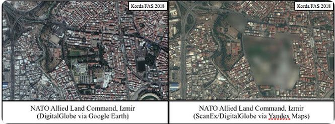
The Federation of American Scientists (FAS) said Russia's Yandex Maps map service unintentionally revealed the location of hundreds of military facilities in Israel and Turkey, as well as two NATO military bases.
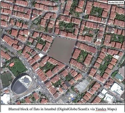
Russia's most popular web mapping application developed by Yandex in 2004 provides detailed maps around the world, including street views and traffic jam information. Some portions of the terrain in Israel and Turkey are clearly "blurred" on the Russian service map application.

Compare images from Google Earth and Yandex Maps.(Photo: Matt Korda).
The FAS report said, when comparing images from Google Earth and Yandex Maps , it is possible to identify many military locations, including large airports, ports and completely secret bunkers. In total, FAS experts found about 300 such locations.
"In the list of blurred locations of Yandex with at least two NATO facilities: the Allied Land Command (LandCOM) in Izmir and Incirlik Air Base of NATO" , according to the FAS report.

The blurred locations on Yandex Maps certainly carry a military function.(Photo: Matt Korda).
Meanwhile no Russian facility has been blurred, including "nuclear facilities, submarine bases, air bases, launch sites or many foreign military bases in Eastern Europe, Central Asia." or Middle East ".
FAS also mentioned in the report that almost all of Syria's territory is described in "extremely low resolution, making it almost impossible to use Yandex to analyze Syrian images".
- The mystery of the secretive US research base
- How to see the Moon, Mars with Google Maps
- The US banned Google from taking military-related photos
- The oldest map in the world sells for 8.5 billion
- How does Google Maps work?
- Map reveals the location of bacteria and chemicals on the human body
- Map reveals the most polluted countries on the planet
- How to use Google Maps where there is no Internet
- Scientists unknowingly found a way to break the baldness
- Small weapons like insects can destroy humanity
- Microsoft provides 3D online maps
- Mysterious ancient maps
 What is the Snapdragon SiP chip?
 How to create a yellow circle around the mouse cursor on Windows
 Edit the Boot.ini file in Windows XP
 3 ways to restart the remote computer via the Internet