Storm and low pressure, Central rain again
According to the Center for Meteorological and Hydrological Forecasting, October 11, a tropical depression intensified into a storm off Central Philippines, becoming the 20th storm of this year, with its international name BANYAN. .
It is forecasted that in the next 2-3 days, typhoon BANYAN will move west and northwest, about 10 km per hour and most likely to enter the South China Sea.
In addition to Typhoon BANYAN, currently in southern Hainan Island (China) is operating a tropical depression , strong intensity level 6, shock level 7. This tropical depression will move in the direction of west and west north, going to the North Central Coast and weakening into low pressure area.
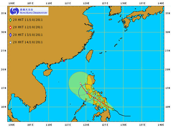
The road map of Typhoon Banyan was updated at 10 pm on October 11, 2011 (9.3 N, 127.3 E)
(Source: Hong Kong Meteorological Agency forecast page)
Due to the effects of tropical depressions, in the southern Gulf of Tonkin there are strong winds of level 5, level 6, shock level 7; The sea is quite strong. Central, Central Highlands and Southern regions have rain, scattered with moderate rain, there are places with heavy rain.
From October 14, when Typhoon BANYAN crossed the Philippines into the South China Sea, in the east and the middle of the East Sea, stormy winds will gradually increase to level 8, level 9, level 10 and level 11; The sea is very strong.
In the coming days, the flood waters of the Mekong River will be little changed, the interior of Dong Thap Muoi (EIA) and Long Xuyen Quadrangle will continue to rise, after slow and high changes.
- Seventh storm weakened into low pressure, from the afternoon of August 28, Bac Bo had a large rain
- This morning, the storm started to cause rain in the Central region
- Appearing low pressure area on the Gulf of Thailand, the Central continued heavy rain
- Low pressure to become a storm, landed in Ha Tinh - Quang Binh
- Strong tropical depression into storm No. 1 (Typhoon Bolaven), toward the South Central
- Storm No. 6 weakened into a low pressure area, the North continued heavy rain
- Storm No. 6 and cold high pressure will cause rain in many places
- Tin latest storm No. 3: Lightning storms landed in Hai Phong - Ninh Binh
- From 3/5, the North has a large rain
- The Central Highlands and the South appear rotten season
- Storm No. 7 is complicated, causing widespread rain
- Central Vietnam reduces the hot sun, the North continues to rain, there is a place where rain is very big
 Is the magnetic North Pole shift dangerous to humanity?
 Washington legalizes the recycling of human bodies into fertilizer
 Lightning stone - the mysterious guest
 Stunned by the mysterious sunset, strange appearance