Storm No. 10 can move north
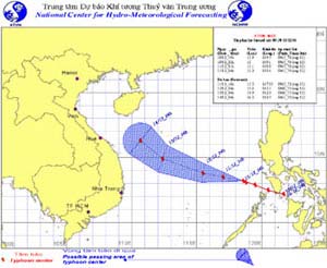
This morning 11/12, storm No. 10 had new developments. Yesterday, the storm mainly moved in the direction of West-Northwest, but today it appears that the storm may move in the North and then move to the Northeast. However, this possibility only has a probability of 50%, and the forecast of the 10th hurricane path will certainly change, and sticking to the situation of the storm is very urgent.

The path of Typhoon Utor according to the forecast of the Hydrometeorological Center
Currently, the continuous strong northeast monsoon winds are also a form that can cause heavy rain in the Central region, but according to the folk experience every 23 October lunar calendar (ie on Wednesday, on 13/12 calendar year this year), Central Vietnam often has heavy rain causing big flood, in addition to fiercely preventing storms, it must pay great attention to the situation of rain and flood.
This morning (December 11), the Ministry of Defense's Search and Rescue and Flood Prevention and Rescue Board has convened millions of meetings to deploy the Prime Minister's electricity, drawing lessons from the storm No. 9 to be a lesson for plan to prevent storm No. 10 of the Ministry. Lieutenant General Nguyen Duc Soat, Deputy General Staff, emphasized that the reason for the storm No. 9 without boats and ships damaged by the sea, was due to the early deployment, continuous monitoring and active control over the situation, informing each fisherman and take resolute measures to bring them to the mainland.
But when entering the mainland because the anchoring was too focused, improper, evacuating people early and not resolute, many people still arbitrarily took to the road when stormed, leading to many losses on land. On the last night, the Ministry of Defense directed continuous fire and storm signaling at stations, river, sea and coastal areas, sending mobile ships to the sea to help relatives and prevent boats from going out to sea. .
Also in this morning, the Central Steering Committee for Flood and Storm Control continued the meeting to implement measures to cope with the storm No. 10 in the new situation chaired by the Minister of Agriculture and Rural Development Cao Duc Phat. During the meeting, the Minister also emphasized that although the storm is likely to go north, the shore is still threatened because the road may be like the last 8 years storm, though it is more than 100 km from the shore but still causing rain. big, big wind and heavy damage to the central coastal provinces .
The steering committee has sent two delegations to the central provinces to direct and urge localities to implement measures to cope with the storm No. 10.
- Mujigae storms move faster and stronger
- Influence of typhoon Kalmaegi, from the north there is heavy rain
- Storm No. 6 weakened into a low pressure area, the North continued heavy rain
- Standing still for 24 hours, storm No. 4 is about to accelerate
- Storm No. 12 weakens into a tropical depression
- Typhoon Kalmaegi directly affects the North
- Thunderstorm speed accelerated deep into the Gulf of Tonkin
- Level 14 typhoon is about to affect the North
- East Sea welcomes storms, Bac Bo heavy rain
- Thunder Gods threaten the North
- Thunderstorm storms straight into Quang Ninh
- Typhoon 4 advanced quickly to the mainland
 Is the magnetic North Pole shift dangerous to humanity?
 Washington legalizes the recycling of human bodies into fertilizer
 Lightning stone - the mysterious guest
 Stunned by the mysterious sunset, strange appearance
 2024 Atlantic Hurricane Season Ends, Leaving Widespread Damage in Its wake
  Storm No. 9 Manyi, level 12, about 200km from Hoang Sa archipelago
  Video: Close-up of the terrible path of the Habood dust storm, causing 15 thousand people in the US to lose power
  Typhoon Tra Mi forms in the East of the Philippines, likely to strengthen into a hurricane when entering the East Sea
  Storm Trami will reach its maximum intensity when it approaches the Paracel Islands.
  Storm Tra Mi enters the East Sea today, strange movement direction