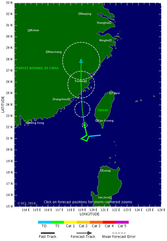
Storm No. 5 is directed at China
At 10 o'clock on 9-9, the location of the storm center number 5 is about 310 km southeast of Guangdong Province (China). The strongest winds in the area near the storm center are strong at level 8 (ie 62 to 74 km / g), level 9 and level 10 jerks.

It is forecasted that in the next 24 hours, the storm will move in the direction between North Northwest and North, about 15-20 km per hour. At 10 am on September 10, the location of the storm center is in the territory of Fujian Province (China). The strongest wind in the area near the storm center is strong at level 8 (ie 62 to 74 km / g), level 9 and level 10. The storm from the center of the storm, the dangerous windy zone from level 6 or higher has a radius of about 200 kilometer.
In the next 24 to 48 hours, the storm moved in the direction of North and North Northeast, about 20 km per hour, going deep into the mainland and weakening into tropical depression. By 10am on September 11, the position of tropical depression on the territory of Zhe Jiang province (China). The strongest wind in the area near the center of strong tropical depression at level 6 (ie from 39 to 49 km per hour), level 7, level 8.
Due to the impact of the storm, the North East Sea (including the southeastern sea of Guangdong Province) has strong winds of level 6, level 7, the area near the center of strong storm level 8, level 9, level 10. The sea is very strong.
- Storm level 10 is directed at Quang Ninh - Hai Phong
- Storm No. 4: Constantly calling for shelter boats
- The strongest storm of the year landed in China
- Super hurricane Utor into China
- Hurricane number 11 advanced quickly into the South China Sea
- Hurricane number 2 - level 9 - 10 directed at Thanh Hoa to Ha Tinh
- Storm No. 6 is approaching the Vietnam-China border, the North is about to rain very hard
- Storm No. 13 could change direction, targeting Central
- Images of Haikui storm landed in China
- Image: Strong storm devastating eastern China
- A strong storm of level 14 appeared in the South China Sea
- Hurricane Rammasun killed 4 people in China
 Is the magnetic North Pole shift dangerous to humanity?
 Washington legalizes the recycling of human bodies into fertilizer
 Lightning stone - the mysterious guest
 Stunned by the mysterious sunset, strange appearance