Storm No. 8 continues to grow, Hanoi has rain
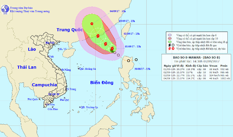
By noon on September 1, the position of the center of the storm was about 19.9 degrees Vi Bac; 118.1 degrees east longitude, about 490km southeast of Hong Kong (China). The strongest wind in the area near the storm center is strong at level 8 (60 - 75km / hour), level 11 is jerky.

Location and path of hurricane number 8.
It is forecasted that in the next 24 to 48 hours , the storm will continue to move in the Northwest direction, 10km per hour. At 10 am on September 3, the location of the center of the storm was about 22.6 degrees north latitude; 115.3 degrees Kinh Dong, on the southeast coast of Guangdong province (China). The strongest wind is in the area near the center of strong storm level 10-11 (90-115km / hour), shock level 13.
Due to the impact of the storm, the North East Sea in the North East Sea has strong winds of level 6-7, the area near the center of the storm passes from level 9 to 10, level 12 jerks; The sea is very strong. In the next 24 hours, the area is dangerous (strong wind from level 6 or higher): north of latitude 17.5 degrees Vi Bac; east of the meridian 115.0 degrees Kinh Dong. Disaster risk level: Level 3.
Center for Hydrometeorology Central warning Hanoi may appear thunderstorms in the inner city such as Ha Dong, Hoang Mai, Long Bien, Hai Ba Trung, Hoan Kiem .
- Tropical depressions intensified into storm No. 8
- Level 14 typhoon is about to affect the North
- Storm No. 5 will enter Hanoi at 15-16 this afternoon
- Plants poured massively on Hanoi street
- Hanoi put a lot of effort against storm Nesat
- The center of Hanoi's old town continues to flood deeply in the sea
- Warning: Storm No. 2 intensifies, Hanoi rains heavily this afternoon
- Influence of No. 2 storm: Hanoi prolonged heavy rain, many streets were submerged in the sea
- Storm Dianmu accelerated, Hanoi prepared to catch a storm
- Storm No. 6 is approaching the Vietnam-China border, the North is about to rain very hard
- Hurricane No. 3, level 14, is approaching Quang Ninh - Thanh Hoa
- Storm No. 3 will sweep through Hanoi, the closer it gets to the shore
- Central Vietnam reduces the hot sun, the North continues to rain, there is a place where rain is very big
 Is the magnetic North Pole shift dangerous to humanity?
 Washington legalizes the recycling of human bodies into fertilizer
 Lightning stone - the mysterious guest
 Stunned by the mysterious sunset, strange appearance