Hurricane No. 3, level 14, is approaching Quang Ninh - Thanh Hoa
The lightning god storm is moving, about 15-20 km every hour, going into the northern Gulf of Tonkin waters and will continue to grow stronger.
Latest information from the Center for Meteorological and Hydrological Forecasting, in the last 6 hours, storm No. 3 moved in the southwest direction, speed of 15km / h. about 20.6 degrees North latitude; 110.0 degrees Kinh Dong, on the area of Lei Chau Peninsula (China). The strongest wind is in the area near the center of the typhoon with a strong level of 8-9 (60-90km / hour), level 10-12 shock.
The forecast for 12 hours , the storm moves in the West-Southwest direction, every hour is about 15-20km, going into the North Sea of Tonkin Gulf and continuing to grow stronger. At 4:00 on August 19, the location of the center of the storm was about 20.4 degrees Vi Bac; 108.2 degrees Kinh Dong, in the North Sea of Tonkin Gulf. The strongest wind is in the area near the center of the storm with a strong level of 10 (90-100km / hour), level 12-14.
From tonight (August 18) , due to the impact of typhoons, in the Gulf of Tonkin (including the districts of Bach Long Vi, Cat Hai, Co To and Van Don), the wind will gradually increase to level 6-8. the area near the center of the storm passes through 9-10 level, shocking level 12-14, sea waves 4-6m high. The sea is very strong. Level 3 disaster risk level.
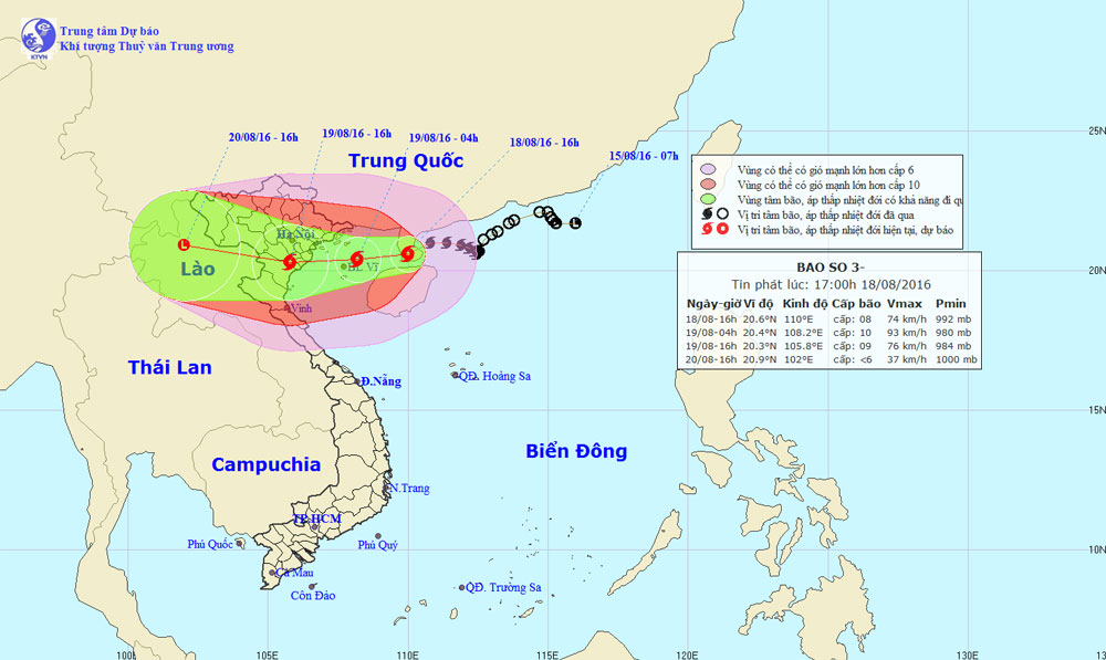
The location and expected path of the storm.(Photo: nchmf).
In the next 12 to 24 hours , the storm moved west-southwest, about 15-20km per hour, going into the mainland with the strongest winds of level 10, directly affecting the northern provinces of Northern Vietnam and North Central. The strongest wind in the area near the center of the storm passes through strong levels of 9-10, level 12-14.
At 16:00 on August 19 , the location of the center of the storm is about 20.3 degrees Vi Bac; 105.8 Kinh Dong, on the mainland of the eastern provinces of the North and Thanh Hoa.
From tomorrow morning (August 19) , the areas of Quang Ninh, Hai Phong, Thai Binh, Nam Dinh, Ninh Binh and Thanh Hoa provinces will have strong winds up to level 8-10, level 12-14. Other places in the plain, midland of North and Nghe An, Ha Tinh have strong winds of level 6-7, level 8-11. The coastal area from Nam Quang Ninh to Nam Dinh has storm surge water combined with 3-4m high tide. Level 3 disaster risk level.
In the next 24 to 48 hours , the storm moved mainly in the West, then the West Northwest, continuing to directly affect the provinces in the North East and North Central. After that, the storm went deep into the land and weakened into a tropical depression, then a low pressure area on the upper part of Laos. The strongest wind in the center of the low pressure area falls below level 6 (below 40km / hour).
The areas of Quang Ninh, Hai Phong, Thai Binh, Nam Dinh, Ninh Binh and Thanh Hoa provinces have strong winds of 8-10 degree, shock level 12-14. Other places in the Eastern North, Nghe An and Ha Tinh have strong winds of level 6-7, level 8-11. The coastal area from South Quang Ninh to Bac Thanh Hoa has storm surge water combined with 3-4m high tide. Level 3 disaster risk level.
- Storm No. 1 attacked Quang Ninh, Hai Phong
- Typhoon hit Quang Ninh
- Directly - Hurricane Kalmaegi approaches Quang Ninh - Hai Phong
- This afternoon, Typhoon Nesat landed in Quang Ninh - Nam Dinh
- Storm No. 10 entered Thanh Hoa-Quang Binh, the strongest in many years
- Quang Ninh suddenly interested in Typhoon Haiyan
- This evening the storm directly affects Quang Ninh - Hai Phong
- Storm level 10 is directed at Quang Ninh - Hai Phong
- Quang Ninh to Quang Ngai is directly affected by typhoon Kai-Tak
- This afternoon and evening, the storm No. 4 will land on land
- Typhoon hit Quang Ninh, Hai Phong
- Typhoon Vincente hit China
 Is the magnetic North Pole shift dangerous to humanity?
 Washington legalizes the recycling of human bodies into fertilizer
 Lightning stone - the mysterious guest
 Stunned by the mysterious sunset, strange appearance