Super Typhoon Ragasa is expected to move into the East Sea late Monday night with sustained winds of 202–220 km/h, becoming the ninth storm to affect Vietnam this year.
See also: Super Typhoon Mangkhut jumped above level 17, accelerating into the South China Sea.
According to the National Center for Hydro-Meteorological Forecasting, on Monday morning, the storm was about 230 km from Luzon Island, Philippines, with maximum winds of 221 km/h, moving west-northwest at a speed of 20 km/h.
By early Tuesday morning, Ragasa is expected to be in the northern South China Sea (South China Sea) with sustained winds of 202–220 km/h, maintaining its track and speed, and is likely to intensify. By 1 a.m. Wednesday, the storm is expected to be about 490 km east of China's Leizhou Peninsula with winds of 184–220 km/h. A day later, the storm will move east of the peninsula with winds reduced to 150–183 km/h, before turning west-southwest into the Gulf of Tonkin.
 People watch high waves crash into Basco, Batanes province, northern Philippines as Typhoon Ragasa impacts the area on Monday, September 22, 2025. AP Photo
The Japan Meteorological Agency forecast maximum winds of around 198 km/h on Monday and Tuesday, before and after the system moves into the South China Sea. The Hong Kong Observatory forecast winds could reach 230 km/h.
The forecast tracks are slightly different. The JMA expects the typhoon to make landfall on the Leizhou Peninsula before moving into the Gulf of Tonkin, while Hong Kong's forecast is for the typhoon to make landfall on the Guangdong coast, then turn towards Leizhou and into the Gulf.
Hoang Phuc Lam, deputy director of the National Center for Hydro-Meteorological Forecasting, outlined two scenarios on Sunday. If the storm turns toward Guangdong, it will likely weaken before entering the Gulf of Tonkin. If the storm moves westward, lower in the sky, the weakening will be less pronounced, bringing stronger winds and higher waves into the Gulf. In that case, the northern and central coasts of Vietnam could be hit by very strong winds and heavy rain.
A seasonal cold air mass is moving down to northern Vietnam. The interaction of this cold air mass with the storm in the coming days could complicate the path and intensity of Ragasa, adding to the uncertainty over the next three days, Mr. Lam added.
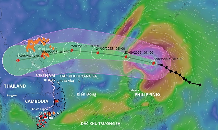 Projected path of Super Typhoon Ragasa. Graphic courtesy of Vietnam National Disaster Management System
Ragasa formed from a tropical depression on the evening of September 18 and intensified to a Beaufort scale eight in just four days to become a super typhoon.
Vietnam's National Civil Defense Committee is scheduled to meet on Monday afternoon with relevant agencies to discuss response measures.
In 2024, the Northwest Pacific recorded three super typhoons, defined as having maximum sustained winds of at least 201 km/h: Yagi, Gaemi and Krathon. Yagi made landfall in northern Vietnam, bringing strong winds, landslides, flash floods and severe flooding. The storm killed 318 people, left 26 missing and caused nearly 84 trillion VND (3.2 billion USD) in economic damage to Vietnam.
From October to December, meteorologists forecast more storms and tropical depressions off the coast of Vietnam than the multi-year average, typically more than four storms with nearly two making landfall.
Flash flood and landslide warning
There is a high risk of heavy rain, flash floods and landslides in the northern mountainous provinces of Lai Chau, Dien Bien, Son La, Lao Cai and Tuyen Quang.
NCHMF forecasts that from 4:40 a.m. to 9:40 a.m. on Monday, the provinces will continue to have rain with common accumulated rainfall from 10-40 mm, in some places over 80 mm.
There are warnings of the risk of flash floods on small rivers and streams and landslides on steep slopes in many communes and wards.
Flash floods and landslides can cause very serious impacts on the environment, threaten human lives, disrupt local traffic, impede vehicle movement, destroy public and economic infrastructure, and cause damage to production and socio-economic activities.
The center recommends that local authorities review areas with blocked streams and vulnerable locations to take preventive and response measures.
From midnight to 3 a.m. Monday, provinces with moderate to heavy rainfall included Nam Xe 1 (Lai Chau) with 47.8mm; Muong Pon 2 (Dien Bien) - 99mm; Pha Khinh (Son La) - 63.2mm; Tan Tien (Lao Cai) - 70mm; and Tung Ba 1 (Tuyen Quang) - 93.4mm.
Soil moisture models show that some areas in these provinces are near saturation (above 85 percent) or already saturated.
The National Center for Hydro-Meteorological Forecasting (NCHMF) said that at 1 a.m. this morning (September 24), the central area of the East Sea, the northern part of the Gulf of Tonkin and the sea area from Gia Lai to Ca Mau will have scattered showers and thunderstorms, with waves over 2 meters high.