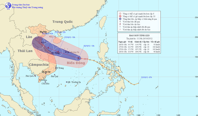
Tom Tinh storms tomorrow night into Central Vietnam
At 10 am on October 26, the location of the storm center is about 14.7 degrees Vi Bac; 114.9 degrees Kinh Dong, about 370 km from Hoang Sa archipelago to the southeast. The strongest wind is in the area near the center of strong storm level 9, level 10 (ie from 75 to 102 km an hour), level 11 and level 12 jerks.
It is forecasted that in the next 24 hours, the storm will move in the direction of West and Northwest Northwest, each hour can travel about 20-25 km and has a stronger ability. At 10 am on October 27, the location of the center of the storm is about 16.3 degrees Vi Bac; 109.8 Kinh Dong, about 150km from the coast of Thua Thien Hue - Quang Ngai provinces to the East. The strongest wind in the area near the storm center is strong level 10, level 11 (ie from 89 to 117 km per hour), level 12 and level 13 jerks.

Photo of the path and location of the storm
In the next 24 to 36 hours, the storm moves mainly in the West-Northwest direction, about 20 - 25km per hour. At 22:00 on October 27, the location of the center of the storm is about 17.3 degrees Vi Bac; 107.3 degrees Kinh Dong, on the coast of Nghe An - Quang Tri provinces. The strongest wind in the area near the storm center is strong level 10, level 11 (ie from 89 to 117 km per hour), level 12 and level 13 jerks.
In the next 36 to 48 hours, the storm moves mainly in the direction of the West-North West, about 20 to 25 km per hour. Enter the mainland and weaken into tropical depression. By 10 am on October 28, the position of the tropical depression center was about 18.6 degrees North latitude; 104.8 degrees Kinh Dong, in Central Laos. The strongest wind in the area near the center of strong tropical depression at level 6 (ie from 39 to 49 km per hour), level 7 jerks.
In the next 48 to 72 hours, tropical depressions move in the direction between Northwestern West and Northwest, about 15km per hour.
Due to storms, Hoang Sa archipelago has strong winds of level 6, level 7, after rising to level 8, level 9, the area near the center of storm passes through level 10, level 11, shock level 12, level 13. Sea violently. From tonight, the waters off the provinces from Quang Tri to Quang Ngai; From tomorrow (October 27) the Gulf of Tonkin waters will gradually increase to level 6, level 7, then increase to level 8, level 9, the area near the center of the storm passes through level 10, level 11, level 12 jerk, level 13. The sea is intense.
The coastal areas from Thanh Hoa to Thua Thien Hue from the afternoon of the wind will gradually increase to level 6, level 7, the area near the storm center will go through strong 9, level 10, level 11 and level 12. The southern plain area The North and the provinces from Thanh Hoa to Thua Thien Hue have moderate rain and heavy rain. Other places in the North have rain, moderate rain, there are places with heavy rain and thunderstorms.
- 12th night storms landed in Central Vietnam
- Northern tomorrow night thunderstorms, hot sunshine ended
- Why are storms in Vietnam so good in Central Vietnam?
- From tomorrow night, the North rains heavily
- Typhoon Nakri approached Quang Ngai - Khanh Hoa, the central region had heavy rain
- Son Tinh storms weakened into low pressure, North Trung Bo was heavy rain
- Hanoi continues to be very hot
- Low pressure to become a storm, landed in Ha Tinh - Quang Binh
- Quang Binh has a big power outage, and Ha Tinh has lost its telecommunication waves
- The Storm of the Mountain Is Focusing on Central
- Emergency response to isolated residential areas after floods
- Son Tinh storm swept through the Philippines, 6 people died
 Is the magnetic North Pole shift dangerous to humanity?
 Washington legalizes the recycling of human bodies into fertilizer
 Lightning stone - the mysterious guest
 Stunned by the mysterious sunset, strange appearance