The Storm of the Mountain Is Focusing on Central
Due to the influence of typhoon No. 8 in Hoang Sa, there was a strong wind of 13m / s (level 6), a shock of 24m / s (level 9), on Ly Son island (Quang Ngai) with strong winds of 13m / s (level 6), jerk 16m / s (level 7); In the provinces from Quang Tri to Binh Dinh, there was moderate rainfall, heavy rain with rainfall from 30 - 50mm; some places have heavier rains like Tp.Hue 73mm; Quang Ngai 126mm; Ly Son 65mm .
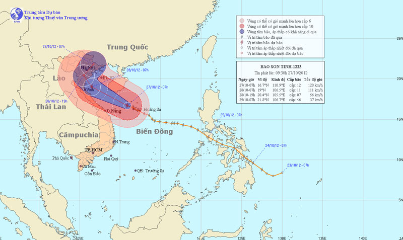
At 07:00 on October 27, the location of the storm center is about 16.7 degrees Vi Bac; 110.9 Kinh Dong, on the western part of Hoang Sa archipelago, about 280km from the coast of Thua Thien Hue - Quang Nam provinces to the east and northeast. The strongest winds in the area near the storm center are strong at level 12 (ie between 118 and 133 km per hour), jerky level 13, level 14.
It is forecasted that in the next 24 hours, the storm will move in the West-Northwest direction, about 20 - 25km per hour. By 07:00 on October 28, the location of the storm center was about 19.0 degrees North latitude; 106.5 degrees Kinh Dong, about 90km from the coast of Thanh Hoa - Nghe An provinces to the East. The strongest winds in the area near the storm center are strong at level 11, level 12 (ie from 103 to 133 km per hour), jerky level 13, level 14.

Photo of the path and location of the storm
In the next 24 to 36 hours, the storm moved in the direction between Northwest and North Northwest, about 15km per hour, going into the mainland and weakening into a tropical depression. By 19:00 on October 28, the position of the tropical depression center was about 20.4 degrees north latitude; 105.5 degrees Kinh Dong, in the areas of Thanh Hoa province and South of the Northern delta. The strongest wind in the area is near the strong center of level 6, level 7 (ie from 39 to 61km per hour), level 8.
In the next 36 to 48 hours, the tropical depression changes its direction in the direction of North East North, about 10 - 15km every hour, going deep into the land and weakening into a low pressure area. By 07:00 on October 29, the central location of the low pressure area is about 21.8 degrees Vi Bac; 106.7 degrees Kinh Dong, in the area of the Northeast mountainous provinces. The strongest wind near the center of the low pressure area falls below level 6 (ie below 39km per hour).
In the next 48 to 72 hours, the low pressure area moves in the northeast northeast, weakens and fades.
Due to the impact of storms, the sea area of Hoang Sa archipelago today (October 27), there are strong winds of level 9, level 10, the area near the center of the storm passing through level 11, level 12, level 13 and level 14. The sea is rough. violently, the waters off the provinces from Quang Binh to Thua Thien Hue have strong winds of level 7, level 8, and then rise to level 9, level 10, the area near the center of the storm passes level 11, level 12, level 13, level 14. The sea is fierce; In the Gulf of Tonkin area from the afternoon and tonight, the wind will gradually increase to level 7, level 8, then increase to level 9, level 10, the area near the center of the storm will go through level 11, level 12, level 13, level 14. Sea violently.
The coastal areas of the provinces from Quang Ninh to Nghe An from early morning (October 28) have strong winds of level 6, level 7, the area near the center of the storm passes through level 8, level 9, level 10 and level 11. The Northern Delta provinces from tomorrow morning (October 28) have level 6 and level 7 gusts. The area in the North East and North Central region has heavy to heavy rain. In the North of the North and the provinces from Quang Binh to Thua Thien Hue, there is a moderate rain, heavy rain, a place with very heavy rain.
- This morning, the storm started to cause rain in the Central region
- 12th night storms landed in Central Vietnam
- Storm and low pressure, Central rain again
- Storm No. 1 entered the Central Coast
- 20 people died, 17 went missing because of Hurricane Damrey
- In the morning, Typhoon Podul landed in the Central Region
- Beam of photos: The wild scenery where the storm No. 10 swept through
- Suddenly No. 6 storm
- Hurricane Podul, level 10, is heading into the South China Sea
- See the smallest mountain range on the planet
- Storm No. 4: Constantly calling for shelter boats
- Hurricane No. 7 entered Central Vietnam early, people could not keep up
 Is the magnetic North Pole shift dangerous to humanity?
 Washington legalizes the recycling of human bodies into fertilizer
 Lightning stone - the mysterious guest
 Stunned by the mysterious sunset, strange appearance