Typhoon does not pour into Vietnam, hot sunshine ends
Earlier today, the first storm on the East Sea maintained level 8 and the possibility of the next 12 hours will enter Guangdong province (China). Meanwhile, a part of cold air has flooded into the North of our country, ending the hot sun.
>>> Tropical depression intensifies into a storm
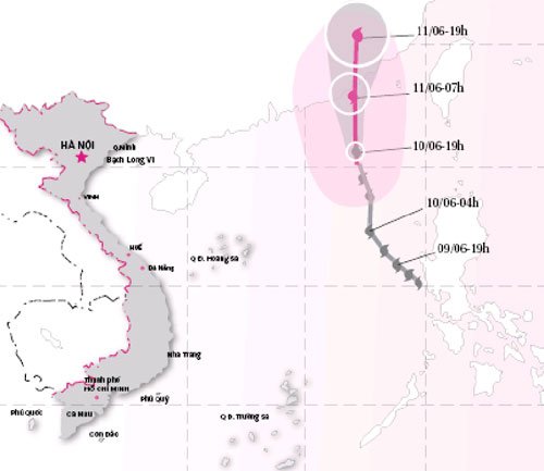
The central hydro-meteorological center said that at 4 am this morning, the storm was on the sea of Guangdong Province (China), strong at level 8. The possibility of storms going straight north now, speed of 20 km each now and land in Guangdong province.
Today the North Sea also has strong winds of level 6-7, strong seas. In addition, due to the combined effect with the southwest monsoon, the southern region of the South China Sea (including the Spratly waters), the waters of the provinces from Binh Thuan to Ca Mau have strong winds of level 5-6, thunderstorms strong.

Evolution and forecast of the path of storm No. 1
(Source: Central Center for Hydrometeorological Forecasting)
Formed from a tropical depression on June 9, the first storm on the South China Sea has a small intensity (only level 8), a short life cycle and hardly affects Vietnam.
According to the Central Hydrometeorological Forecast Center, last night the compressed and pushed low-pressure cold air division moved south, so soon Hanoi and the northern provinces cool and ended. the first heat wave in June.
It is forecasted that in the next 2-3 days, due to the impact of cold air, the North will have showers and thunderstorms, mountains may have heavy rain. The temperature in Hanoi varies from 25-33 degrees Celsius.
Due to the low pressure being pushed down to the south, the North and Central Central provinces today continue to be hot, the highest temperature is 35-37 degrees Celsius. Tomorrow, this region's weather will be comfortable thanks to the showers and thunderstorms.
- Vietnam may face new super typhoons
- Typhoon Sarika will land in Vietnam
- In the next 24 hours, the mind of the super typhoon Haiyan enters the waters of Hue-Binh Dinh
- Linfa storm changed direction, could affect Vietnam
- Hot sunshine, Hanoi is as empty as ... Ba Danh pagoda
- Typhoon Haiyan is heading into Quang Ngai
- Haiyan storm left Vietnam, at least 13 people died
- Behind the lovely sunshine doll of Japanese people is a pretty scary story
- Typhoon Haiyan weakens gradually and goes to China
- On December 10, Typhoon Utor will enter the East Sea
- Typhoon Gaemi will land in Central Vietnam
- Northern tomorrow night thunderstorms, hot sunshine ended
 Is the magnetic North Pole shift dangerous to humanity?
 Washington legalizes the recycling of human bodies into fertilizer
 Lightning stone - the mysterious guest
 Stunned by the mysterious sunset, strange appearance