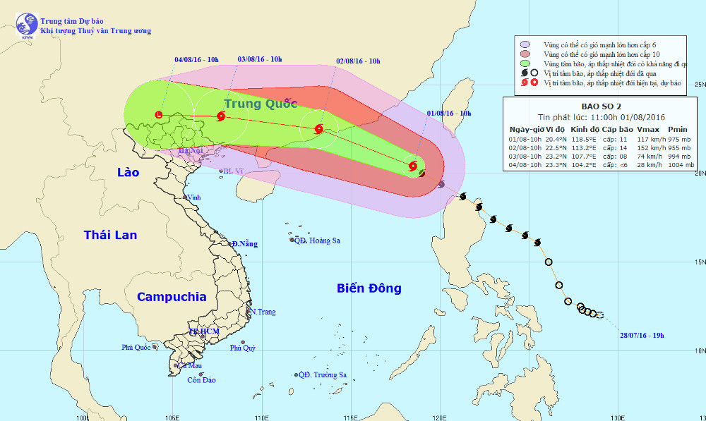
Typhoon Nida entered the South China Sea with 14-15 winds
At 10 o'clock on August 1, the position of the center of the storm was about 20.4 degrees Vi Bac; 118.5 degrees east longitude, about 500 km east of Hong Kong to the southeast. The strongest winds in the area near the center of the storm are strong at level 11-12 (105-135km / hour), level 14-15.
It is forecasted that in the next 24 hours , the storm will move in the West-Northwest direction, about 25km per hour and will continue to increase. At 10 o'clock on August 2, the location of the center of the storm is about 22.5 degrees Vi Bac; 113.2 degrees Kinh Dong on the mainland of Guangdong province. The strongest wind in the area near the storm center is strong at level 13-14 (135-165km / hour), level 16-17.
The East Sea in the East Sea has storms, strong winds of 8-11 level, the area near the center of the storm passes level 11-14, level 16-17. The sea was fierce. Level 3 disaster risk level.

Location and path of super typhoon Nida.
In the next 24 to 48 hours , the storm moves in the West-Northwest direction, 20-25km per hour. At 10 am on August 3, the location of the storm center is about 23.4 degrees Vi Bac; 107.9 degrees Kinh Dong, on the mainland of Guangxi province. The strongest wind is in the area near the center of strong storm level 8 (60-75km / hour), level 9-10.
The North Sea in the East Sea on August 2 also has strong winds of level 8-10, the area near the center of the storm passes level 11-13, level 15-16. The sea was fierce. Level 3 disaster risk level. Northern Gulf of Tonkin area from the evening of 2/8 strong winds of level 8-9. Strong sea. The North East North region has strong winds of level 6-7.
From the night of August 2 , in the North of the Northeast, there is a moderate rain and rain. Particularly, the Northeast area has a very big rain.
In the next 48 to 72 hours , the storm moved in the West, about 15-20km per hour.
In the North, there is a moderate rain to heavy rain, especially in the mountainous and midland areas, there is heavy rain.
In addition, because of the southwest monsoon activity, in the South China Sea region (including the Spratly waters), the offshore waters from Binh Thuan to Ca Mau have strong winds of level 5, sometimes 6, shock level 7-8. The sea is rough.
- Typhoon Linfa has entered the South China Sea
- Typhoon Soudelor entered Taiwan, the South China Sea has strong winds
- Hurricane Nida increased rapidly before entering the South China Sea
- Typhoon Yutu is level 16, entering the South China Sea tonight
- Typhoon Nida hit Hong Kong
- Storm No. 13 could change direction, targeting Central
- Hurricane number 11 advanced quickly into the South China Sea
- Sanba stormed into South Korea, 1100 people evacuated
- Hurricane No. 2, level 10, entered the South China Sea on the days of Tet
- Vietnam may face new super typhoons
- Typhoon Haiyan weakens gradually and goes to China
- Haiyan storm left Vietnam, at least 13 people died
 Is the magnetic North Pole shift dangerous to humanity?
 Washington legalizes the recycling of human bodies into fertilizer
 Lightning stone - the mysterious guest
 Stunned by the mysterious sunset, strange appearance