Visit the ionosphere 4D
NASA has just released the 4D model of the Earth's ionosphere. No need to leave the house, anyone can fly through layers of gas carrying electric charge around the earth. All requests are just your computer connected to the Internet.
'Understanding the ionosphere is very important. That's why NASA's 'Living with a Star' (LWS) program funded this work, 'said Guhathakurta, a LWS scientist. Space Environment Technologies, California State, Space Environment, Utah State and US Air Force developed this program.
Lika Guhathakurta, a physicist specializing in solar systems at NASA headquarters in Washington, said. 'The ionosphere is very important for pilots, amateur radio users, earth researchers and even soldiers. Using this new 4D tool, they can observe and study the ionosphere they really are inside. '
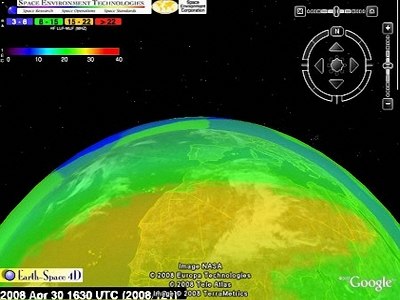
A photo of the ionosphere 4D (Photo: http://science.nasa.gov)
'Colors show the state of electrons', explains W. Kent Tobiska, president of Space Environment Technologies. 'Magenta color indicates dense electrong density, which is where the radio information is slightly restricted or completely lost. Blue means lower density, no matter what happens here. '
Using the Google Earth interface, users can fly over, around or through these areas of electromagnetism and observation with realistic 3-dimensional images. 'Wednesday afternoon is time. It's a real-time system, 10 minutes updated once , ' he said.
The system's unique name is CAPS, short for Communication Alert and Prediction System . Satellites traveling in orbit around the Earth provide a system of up-to-the-minute information about the sun's activity, which is then converted to the density of electrons by computer. It is worth noting that CAPS not only shows the ionosphere in its current state, but it can also tell us what it will look like in the near future.
This ionosphere is considered the final frontier of our planet. It is the last gas layer of the atmosphere, where astronauts leave last before entering the universe. The scope of the ionosphere extends from 50 to 500 miles (about 80 km to 800 km) above the earth's surface, where the gas is nearly vacuum and is in direct contact with the power of the sun. The ultraviolet radiation of the sun separates molecules and atoms to form a layer of fog that covers the earth carrying electrons and ions.
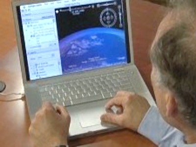
To explore the ionosphere, all requests are just your computer connected to the Internet (Photo: NASA)
The ionosphere is especially important for commercial flights. Using this 4D tool, air traffic controllers can study the ionosphere from the driver's position and use this collected information to predict problems that will occur, from which to control the trip. fly slower or redirect.
Amateur radio users know about this ionosphere very well. They can transfer information across the horizon through reflection of the ionosphere's radio signals - or not when the sun's light source with X-rays disrupts the ionosphere and causes a loss of signal. The ionosphere also has a great impact on the reception of GPS signals (global micro-system). Before the GPS satellite signal reached the ground, it first had to cross this charged gas layer, bent its path, reflected and weakened. The solar wind and storm from upsetting the ionosphere could be the cause of errors in GPS positioning in about 100 meters.
To use, simply follow the instructions:
- Download and install the Google Earth program here
- Click here and click on the link 'Total Electron Content'
Wait for the file to download completely and very soon after, you will find yourself flying through the ionosphere.
- The first ionosphere probe appeared in Tomsk
- Russia - China 'enchantment' atmosphere
- SpaceX's Falcon 9 rocket punctured the Earth's ionosphere
- Tell stories to visit NASA
- Visit the inner planet of the solar system
- Visit the Kennedy Space Center 'visit' Mars
- Why can't Qianlong be away from Hoa Than?
- April 22: Bill Gates will visit Vietnam!
- Former President Bill Clinton came to Vietnam
- Video: Divers running under the water with speed
- What's more than 15 times as many assets as the national treasury of the Hoa Than sightseeing tour?
- Moon historical park: Who wants to visit?
 What is the Snapdragon SiP chip?
 How to create a yellow circle around the mouse cursor on Windows
 Edit the Boot.ini file in Windows XP
 History of formation and development of computers