14-strong strong Nalgae storms towards the East Sea
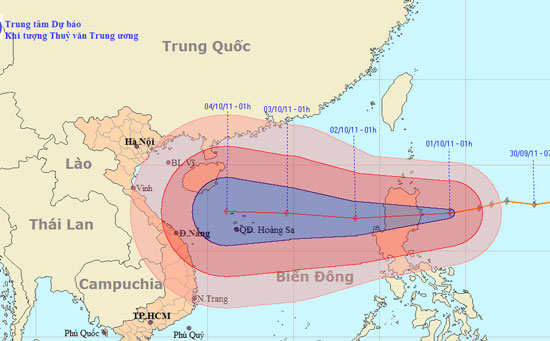
At 1 o'clock on October 1, the location of the center of the storm is about 17.2 degrees Vi Bac; 124.1 degrees east longitude, about 200km from the island of Luke (Philippines) to the east. The strongest winds in the area near storms are strong at level 14, level 15 (ie from 150 to 183km per hour), level 16 and level 17 jerks.
It is forecasted that in the next 24 hours, the storm will move in the direction of West and West Southwest, about 25km per hour. So around the evening and night of October 1, the storm will enter the East Sea in the North East Sea. At 1 o'clock on October 2, the location of the storm center is about 16.9 degrees Vi Bac; 118.6 degrees east longitude, about 700kn east of the Paracel Islands. The strongest wind in the area near the center of the storm is level 13 (ie from 134 to 149km per hour), level 14, level 15.

Beam photos of the path and location of the storm. (Click on the image to see the larger size)
In the next 24 to 48 hours, the storm moves mainly in the West, about 20 km per hour. At 1 o'clock on October 3, the location of the storm center is about 17.2 degrees Vi Bac; 114.6 degrees east longitude, about 250km from Hoang Sa archipelago to the East Northeast. The strongest wind in the area near the center of the storm is level 13 (ie from 134 to 149 km per hour), level 14, level 15.
In the next 48 to 72 hours, the storm continued to move mainly in the West, about 15 to 20km per hour.
Due to the impact of storms, from noon and late afternoon (October 1), the East Sea in the North East Sea has strong winds of level 8, level 9, after rising to level 10, level 11, the area near the center of the storm is strong. level 12, level 13, level 14, level 15. The sea is rough.
The next newsletter is distributed at 9:30 on October 1.
News broadcast at: 3:30
- Strong storms appeared on the East Sea
- The Philippines struggled with the consequences of two storms
- Danas storms level 10 toward the East Sea
- Tropical depressions are likely to become strong storms towards the North
- Storm Nalgae melts at sea
- How was the storm in the East Sea formed?
- A strong hurricane number 10 with level 12 approaches the land
- Strong Banyan storm level 8 on the East Sea
- Typhoon Nari approached the waters of the central provinces
- Storm Nalgae reduced to level 10
- Storm Nari threatened, many Central people evacuated
- The East Sea is about to welcome the 11th storm
 Is the magnetic North Pole shift dangerous to humanity?
 Washington legalizes the recycling of human bodies into fertilizer
 Lightning stone - the mysterious guest
 Stunned by the mysterious sunset, strange appearance