Chanthu storms are 'swinging hammocks' on the East Sea
Newly formed, the storm was straight west, then headed north to China. However, July 20 shows that the storm is stronger and likely to affect Vietnam.
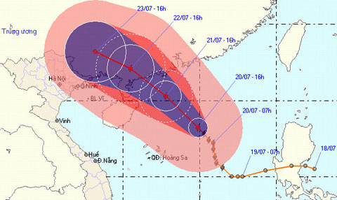
According to the Central Center for Meteorological and Hydrological Forecasting, 16:00 pm on July 20, the storm center is 330 km from Hoang Sa archipelago with wind power increasing by one level compared to this morning, reaching level 9, level 11 shock.
In the next 24 hours, the storm moves mainly in the northwest with a speed of 15 km per hour. On the afternoon of July 21, the storm surged one level and the mind was only about 220 km east of Hainan Island (China).

The storm is proving complicated when constantly changing directions.Photo: NCHMF .
In the next 3 days, the storm will land and weaken into a tropical depression near the Vietnam-China border. Storms are likely to cause heavy rains in the northern mountainous provinces of Vietnam.
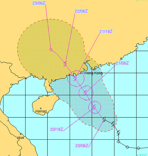
The above forecast of the Vietnam Meteorological Agency is quite similar to the meteorological stations of the US Navy or the meteorological agency of Japan and Hong Kong.
However, when going deep into China and weakening into a tropical depression, Vietnam meteorological station said that low pressure tends to be westward and affect the northern mountainous provinces of Vietnam. While the US Naval Station predicts tropical depressions are less likely to affect Vietnam.

The US Navy's meteorological forecast also showed that the storm could affect North Vietnam.Photo: Unso.
Chanthu appeared almost immediately after Typhoon Conson dissipated and was the second storm to enter the South China Sea this year. This year Vietnam is expected to suffer from 5-6 storms.
Previously, Conson stormed a dead person and 17 missing people, mostly Quang Ngai fishermen in distress while operating in the Paracel Islands area.
- The North will have heavy rain due to storms
- How was the storm in the East Sea formed?
- News of storm near the East Sea: Melor storm
- Tin storm on the East Sea: Typhoon Khanun
- The cause of sand storms raging throughout the Middle East
- A strong hurricane number 10 with level 12 approaches the land
- Strong storms appeared on the East Sea
- Danas storms level 10 toward the East Sea
- Super Typhoon Melor landed in the Philippines, 3 people died
- Three storms converge in northeastern East Sea
- Why lying hammock is easy to sleep?
- Strong Banyan storm level 8 on the East Sea
 Is the magnetic North Pole shift dangerous to humanity?
 Washington legalizes the recycling of human bodies into fertilizer
 Lightning stone - the mysterious guest
 Stunned by the mysterious sunset, strange appearance