Find the culprit who separates England and France
A great river from ancient times caused the displacement of England from France.
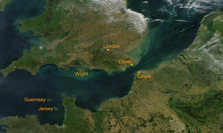
The Sea of Manche is a long stretch of ocean in the Atlantic Ocean that alternates between the English island and the northern coast of France. This sea is 562 km long, in which the largest place is up to 240 km. Many scholars have hypothesized that in the past, Britain was associated with the continent of Europe and that the Manche Sea was just a great river, but for some reason the river swelled to the sea and pushed England away from France. According to Daily Mail, people call that hypothetical river Fleuve Manche (meaning "super big river" in French).
Some previous studies have shown that the river used to exist during the period when the earth freezes 450,000 years ago. It formed when a large glacier in the North Sea (the sea in the north of the Atlantic Ocean) overflowed, creating a massive flood that caused water to penetrate the rocks between England and France.
Geographical experts from Cambridge University (UK) analyzed many samples of sediments they obtained at the bottom of Biscay Bay (located in the northeast of the Atlantic Ocean). Those sediment samples have been lying on the bay for several thousand years.
The analytical results show that Fleuve Manche survived through three glacial periods, during which the last period occurred from 30,000 to 90,000 years ago. (The other two periods appeared from 160,000 and 450,000 years ago).

It is possible that the Manche Sea was only a super river before.Photo: laurinswim.com.
Professor Phil Gibbard, a lecturer in the Department of Geography at Cambridge University, said: 'This is the first time we have studied sediment drifting off the Channel and settling down into the Bay of Biscay in three glacial periods. The result we obtained was the last piece in the complete picture of the events that separated England from Europe and became an island. '
Daily Mail quoted Gibbard as saying that the ice lake in the North Sea is formed between the ice mass in the north and the mainland in the south. Many rivers flow into the lake, causing water to spill out frequently and causing flooding. In two floods such as water overflowing chalk layer (soft, porous, white sedimentary rocks). Due to the soft chalk, the penetration of water caused them to be swept away, creating a long and large trench on the bottom of the Manche Sea today. That trench set the stage for the formation of the river Fleuve Manche.
In three glacial periods, ice covered much of Europe. Since most of the river Fleuve Manche turned into ice, its water level was so low that humans and animals could travel from France to England and vice versa. But during hotter periods, the ice melts causing river water levels to rise. Fleuve Manche swelled out into the sea, making Britain separate from Europe.
- Find the culprit that extends 100 species of frogs
- The culprit of the Plague Battle killed 100,000 people in England
- The danger of humanity is ... people
- Amiante: The culprit causing cancer
- 20 interesting facts about France
- Flash floods caused 1,600 people to evacuate urgently in France
- The 10 most impressive things in France
- Things you may not know about France
- Great storms in France and America
- Unbelievable privileges when you are ... Queen of England
- Appointment online: to the West also
- Cu Chi Tunnels top the world's most implicit underground destination
 Is the magnetic North Pole shift dangerous to humanity?
 Washington legalizes the recycling of human bodies into fertilizer
 Lightning stone - the mysterious guest
 Stunned by the mysterious sunset, strange appearance