Central Center for Hydrometeorological Forecasting said that at 2 o'clock on August 16, the position of the tropical depression center was about 21.8 degrees Vi Bac; 115.2 degrees Kinh Dong, on the waters off Guangdong Province (China).
The strongest wind is in the area near the strong tropical depression at level 6-7 (40-60km / hour), level 9-10.
It is forecasted that in the next 24 hours, tropical depressions will move mainly in the West, 10km per hour and can be strengthened into storms.
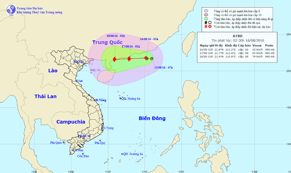
Location and path of tropical depressions.
At 1 o'clock on August 17 , the location of the storm center is about 21.7 degrees Vi Bac; 112.9 Kinh Dong, about 290km from Leizhou Peninsula (China) to the East. The strongest wind is in the area near the center of strong storm level 8 (60-75km / hour), level 10-11.
Due to the influence of the circulation of tropical depression, then strong up into a storm, the North Sea in the East Sea has strong winds of level 6-7, level 8-9 and from tonight (August 16), there is strong wind 8, level 10-11 shock.
There are showers in the Tonkin Gulf and the North Sea area, with tornadoes and strong winds. Level 3 disaster risk level.
In the next 24 to 48 hours, the storm moved in the West, the speed slowed down, about 5-10 km per hour and continued to increase.
Warning in the coming days there is a possibility of large-scale heavy rain in the North and North Central region. Level 2 disaster risk level.
In addition, due to the strong influence of the southwest monsoon, the sea area from Binh Thuan to Ca Mau and the southern area of the South China Sea (including Truong Sa archipelago) has strong southwest wind of level 6, shock level 7 -9, 2-4m high waves, rough seas. Disaster risk level: level 1.