Tropical low pressure will strengthen into storm
After moving very quickly into the South China Sea, the low tropical hamlet slowed down and headed north. It is expected that today low pressure will strengthen into a storm.
With the speed of movement when newly formed 25 km per hour, the tropical depression quickly crossed the island of Luke (Philippines), entering the East Sea. However, in the last 24 hours, this depression decreased in speed and tended to head north.
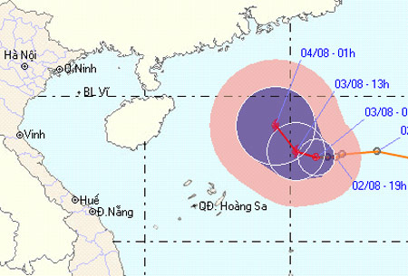
According to the Central Hydrometeorological Center, in the early morning, the tropical depression is located in the North East Sea with wind speed level 9. Low pressure moves slowly in the North-West direction, 5 hours can travel every hour -10 km and potentially increase into a storm. This evening, the storm center is about 430 km east of the Hoang Sa archipelago to the northeast of the Northeast with a level of wind increase.

Tropical depressions tend to move to the north.(Photo: NCHMF)
In the early morning of August 4, the storm center was 380 km east of Hai Nam Island (China) to the east, the wind was unchanged.
On the way of the low pressure, the North East Sea (including the Paracel Islands) has heavy rain, wind level 10. In addition, the sea area from Binh Thuan to Ca Mau has wind gusts to level 9.
The Central Steering Committee for Flood and Storm Control continues to ask coastal provinces from Quang Ninh to Binh Dinh to promptly notify owners of vessels operating on the sea to actively prevent. The vehicles often keep in touch, absolutely do not go to dangerous areas of operation.
- Tropical depressions intensified into storm No. 10
- Hurricane Pakhar and tropical depression are
- This afternoon, the tropical depression strengthened into a storm - the number 9 storm this year
- East Sea is about to catch storms
- When is it called super typhoon?
- Tropical depression strengthened into storm No. 2, heading to Quang Ninh - Hai Phong
- Tropical depression intensified into storm No. 3 - WIPHA storm
- A new low pressure appears, potentially strengthening into a storm
- Strong tropical depression into storm No. 1 (Typhoon Bolaven), toward the South Central
- Tropical depression intensified into a storm - typhoon Kai-Tak
- Tropical depression towards the East Sea
- Storm Dianmu accelerated, Hanoi prepared to catch a storm
 Is the magnetic North Pole shift dangerous to humanity?
 Washington legalizes the recycling of human bodies into fertilizer
 Lightning stone - the mysterious guest
 Stunned by the mysterious sunset, strange appearance