Nearly 7 magnitude earthquake shook Indonesia
The Meteorological and Geophysical Agency with the Indonesian Disaster Response Agency on February 16 announced that a 6.8 magnitude earthquake rocked some of the eastern regions of the country.

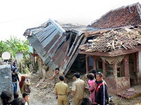
Homes were destroyed in the Indonesian earthquake in September 2009.(Photo: AFP / VNA)
According to the two agencies, the earthquake occurred at 4 51 minutes (local time) on February 16 morning with the epicenter at a depth of 106 km below sea level, 22km from Saumlaki area of the province of Maluku to the northwest.
There is still no information on the number of casualties or earthquake damage and no tsunami warnings have been issued.
However, spokesman for Disaster Response Agency Priyadi Kardono said no one was injured and no buildings collapsed during the earthquake.
Indonesia is the largest island nation in the world, located on the Pacific Ring of Fire, adjacent to the continental plates, so frequent earthquakes and volcanic eruptions occur.
Earlier, in September 2009, the 7.6-magnitude earthquake on the country's island Sumatra killed more than 1,000 people.
- The magnitude 6.2 earthquake shook Indonesia
- Strong earthquakes in the Philippines and Indonesia
- Earthquake disaster in Indonesia: The number of deaths increased to 380
- Earthquake 6.5 degrees shaking Indonesia
- The earthquake shook Indonesia again
- Strong magnitude 6.3 earthquake off Indonesia
- Earthquake shook Indonesia
- The magnitude 7.5 earthquake shook South Asia, at least 100 people died
- Strong earthquake shook Indonesia
- The earthquake shook in Tokyo
- Japan again shook because of the 6.1-magnitude earthquake
- Indonesia, Georgia, Italy ... shook by the earthquake
 Is the magnetic North Pole shift dangerous to humanity?
 Washington legalizes the recycling of human bodies into fertilizer
 Lightning stone - the mysterious guest
 Stunned by the mysterious sunset, strange appearance