Nha Trang 100 years ago through documentary photos
From a small coastal fishing village, Nha Trang City has now developed into a bustling urban area in the South Central region, attracting millions of tourists each year.

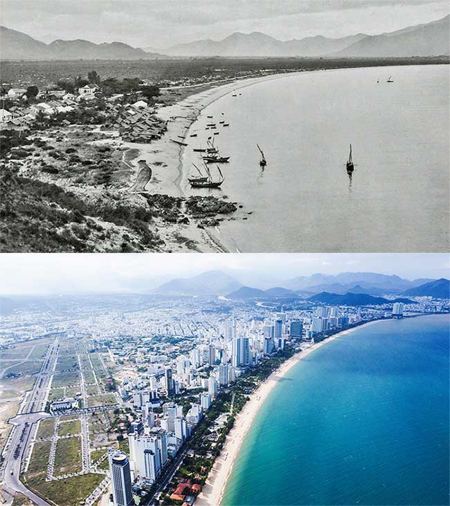
Nha Trang in the years 1920-1929 was a coastal fishing village (now Tran Phu street). Previously, this place was just shabby houses along the sea, people lived by fishing and small businesses. Up to now, the route has a prime location in the city with high traffic density. In 1924, King Khai Dinh issued an edict to establish Nha Trang town. When formed, the town had 4 small villages: Xuong Huan, Phuong Cau, Van Thanh, Phuong Sai. In 1944, this locality was upgraded to a town. On March 30, 1977, the Government Council elevated Nha Trang City to Phu Khanh province. Currently, Nha Trang is a class I urban area, located in Khanh Hoa.

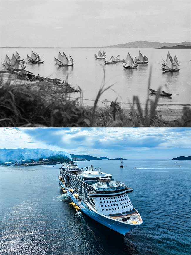
Fishing boats at Nha Trang Bay in 1920-1929. Nha Trang Bay is the second largest in Khanh Hoa province (after Van Phong Bay) with 19 large and small islands. This place has rich natural resources and the first biodiversity marine reserve in the country. Up to now, local authorities have paid special attention to preserving this bay. This is also a place for large international yachts to visit. According to the Department of Tourism, in 2024, Khanh Hoa will welcome 45 cruise ships.

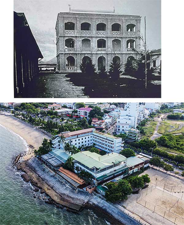
Doctor Alexandre Yersin's house (also known as Ong Tu's floor) in Nha Trang City. In 1891, after arriving in Indochina, Yersin decided to resign from Messageries (Maritime Transport Company - working as a doctor on the ship to Saigon - Hai Phong) to live in Nha Trang. He built a wooden house in Xom Con, opened a clinic, and often treated patients for free, so people loved him and often called him Mr. Tu. This place is currently resort 378 of the Ministry of Public Security, scheduled to relocate to the northern area of Cam Ranh peninsula. In the future, there will be a complex with outstanding works such as Yersin museum (4,000 m2), commercial area, cafe, and beach bar; renovating Yersin park.

Nha Trang Pasteur Institute in 1920-1929. The project was founded by doctor Alexandre Yersin in 1895. Initially, the institute was just an old laboratory with a row of stables. This place is used to prepare medicine, research malaria and other types of bacteria and parasites that cause diseases in humans. In 1975, Nha Trang Pasteur Institute belonged to the preventive medicine system of the Ministry of Health. Currently, the institute has 160 officers and employees, operating areas stretching from Quang Binh to Binh Thuan.

Xuong Huan Lagoon (also known as En Lagoon - many swallows reside), is now the Dam market area in Nha Trang City. According to documents, since around 1908, Nha Trang has had a market formed at the end of En lagoon (near Phan Boi Chau street today). Over time, the population became crowded, goods were traded outside the road, and house construction along the lagoon became chaotic. Therefore, the local government discussed building a new market. From April 12, 1969, the Saigon Water Transport Department used sand to fill the lagoon. After 6 months, the first stone was placed on the vast sand beach, marking the construction of Dam market and on February 22, 1972, the market construction was completed. Dam En is now only in the memories of local people. Currently, Khanh Hoa province has built a new Dam market next to the old Dam round market.

Nha Trang Station in the years 1920-1929. The project was inaugurated on September 2, 1936, with an area of 14.8 hectares. This is the place that marks the scene of Khanh Hoa people fighting against the French colonialists on October 23, 1945. Over decades, the project still retains its French-era architecture, with 5 railway tracks including two main tracks and three loading and unloading tracks. Currently, this place welcomes dozens of trains every day into and out of Nha Trang. In the future, Nha Trang station is planned into a museum, park. The new station will be built in Vinh Trung commune, Nha Trang city.

The Cathedral (also known as the Mountain Church) is at the sixth intersection, center of Nha Trang city. The project has a total area of 720 m2, built in 1928 with ancient Gothic architectural style. This land used to be wild, when the French came to Nha Trang and split Hon Mot mountain in half. The western half of the mountain was flattened by 500 mines to make room for a church. This is a place that attracts many people and tourists to visit, especially on major holidays.

Ponagar Tower is located on Cu Lao hill, next to the Cai River of Nha Trang City. The time the tower was built was also the period when Hinduism was most flourishing in the ancient Champa kingdom. This is a unique and unique architectural complex of the Cham people, ranked as a national historical relic by the Ministry of Culture, Sports and Tourism in 1979. Ponagar Thap Ba Festival takes place from March 21 to 23. lunar year every year. Each year this place welcomes about 1.3 million visitors. In 1925, Xom Bong bridge was built across the Cai River, located next to the Ponagar tower relic. Over a long period of time, the bridge has been degraded many times and rebuilt, most recently last year.

Nha Trang beach in 1968 - (Photo: Clare Love). Up to now, the beach is considered one of the beautiful beaches in the Central region, attracting millions of visitors each year. In the first quarter of 2024, Khanh Hoa welcomed about 650,000 visitors, 2.7 times more than the same period in 2023.

The northern area of Nha Trang, the coastal road passing through Hon Chong, now has many high-rise buildings, attracting many foreign tourists. Over the years, Nha Trang City's economy has developed comprehensively, with an average growth rate of 11.2% per year. According to the general planning project, Nha Trang City is the center for science and technology, education, training and healthcare, seaport services, tourism, trade and finance of the South Central Coast and Central Highlands regions; administrative, economic, cultural, scientific and technical center of Khanh Hoa; plays an important role in national defense and security and marine environmental protection.

Hon Tre is one of the largest islands in Nha Trang Bay, in the years 1967-1969, looking towards Nha Trang City. Up to now, the island has been invested in entertainment and resort areas, becoming an attractive tourist destination for tourists coming to the coastal city.

Con hamlet in 1968 , Nha Trang coastal area, now Tran Phu street. At the river mouth, after many years, Tran Phu bridge was built - the highlight of the sea route in Nha Trang, connecting the two banks. (Photo: Sue Ellen). Khanh Hoa province is implementing Resolution 09 of the Politburo with the goal of becoming a centrally run city by 2030. In particular, Nha Trang is a nuclear urban area, one of the three key socio-economic regions of the province. Mr. Ho Van Mung, Secretary of Nha Trang City Party Committee, said the entire economic sector of the city must be environmentally friendly, have high added value, and the focus is still on developing services and tourism.
- Old New Year Hanoi through precious documentary photos
- Leveling Nha Trang Bay
- Overview of the observatory of the Vietnam Space Center
- People know 'Photoshop' photos from 1902 years
- Behind the ranking of Nha Trang beach
- Nha Trang: organize sea turtle protection activities
- Land loss in Nha Trang caused two casualties
- Many species of seafood in Nha Trang Bay are exhausted
- The charming landscape of Trang An World Heritage Site
- Will build artificial reef models in Nha Trang Bay
- Video: Complete documentary Our Planet - Our Planet
- MH370 was found in a place not in the Cambodian forest
 The 11 most unique public toilets in the world
 Explore the ghost town in Namibia
 Rare historical moments are 'colored', giving us a clearer view of the past
 The world famous ghost ship