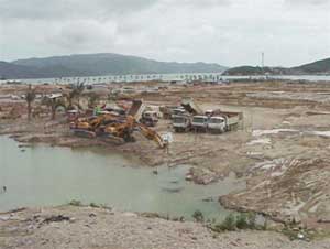
A corner of Nha Trang Bay at Chut Mountain Ring Road (Vinh Nguyen) has been leveled to build a residential area - Photo: Phan Song Ngan
In recent years, the leveling of Nha Trang bay takes place in many places, affecting the landscape and ecological environment of the sea.
Encroachment has not returned
A corner of Nha Trang Bay at Chut Mountain Ring Road (Vinh Nguyen) has been leveled to build a residential area - Photo: Phan Song Ngan
In the Rusalka project area at Bai Tien, in Vinh Hoa ward, north of Nha Trang bay, in addition to the allocated sea and beach area, 'investors' arbitrarily encroached and leveled nearly 23,000. m2 of sea surface.
Last July, Khanh Hoa Provincial People's Committee requested to restore the original status of 14,652 m2 of sea filled. But so far the 'order' of the province has not been implemented by the 'project owner' Nguyen Duc Chi who is in prison.
In the nearby Duong De area, over 30 hectares of sea surface were also jointly partnered by a partner of Nguyen Duc Chi (Rusalka) of Lam Vien Company and Khanh Hoa Cadastral Public Company. residential area project.
Song Lo sea in the southern part of Nha Trang Bay is also encroached and leveled. Here, in addition to an area of more than 170 hectares has been assigned to the Song Lo tourist and entertainment zone project, Khanh Hoa province, for Hoan Cau Company Limited to hire more than 148 hectares of sea surface.
And the company has dumped the seafloor with an area of 30,000m2 and dredged mud to cover the sea encroachment by about 20,000m2 . But since the Inspectorate of Department of Natural Resources and Environment discovered the punishment. That administrative violation (July 2004) until now Nha Trang Bay has not been completely returned to the lost sea.
Too much loss!
Mr. Le Van Ke, former chairman of Khanh Hoa Provincial People's Committee, said: ' From the French period until before 1975, most streets of Nha Trang were built by houses planning almost perpendicular to Nha Trang beach and equally. running diagonally in the southeast from the sea and along the whole city . Thanks to planning, such design helped the sea breeze, the fresh air of the sea pushed into divided areas for many residential areas in the way far away and deep in the city. In planning and in fact, there was absolutely no high-rise building allowed to grow along the coastal road, which is the 'front' of the whole Nha Trang city. . '.
In the area of Chut Mountain Ring Road, south of Cau Da, an entire area of Nha Trang Bay with a width of 56 hectares is located near the Tac River mouth (Quan Truong) being completely leveled to establish Phu Quy residential area (nearly 80ha ) with a population of 12,000 people.
Leveling has affected the lives of many residents because of pollution. At the same time, according to the port of Nha Trang, the sea area is closed to the edge of the flow and tidal currents; Only from the flow of the ship which has been dredged and the bridge of 20,000 tons are under construction of Nha Trang port 300-1,000m, there is a risk of sedimentation for ships and wharves of Nha Trang port.
According to the leadership of Nha Trang Bay Management Board, the above sea leveling has created a number of threats to the ecosystems of the bay. Increased sediment deposition will kill all the corals in the bay and alter the flow in the marine protected area . harming both the landscape and the marine environment.
The sea level is leveled up due to the construction of projects for tourism business not only in coastal areas but also quite scale even outside the island, located in Nha Trang bay conservation area.
A huge marine ecoregion in Dam Gia area (belonging to Hon Tre) has now been destroyed because the project owner on the island dumped rocks directly into the sea, burying all sea grasses, corals and values. Other marine ecology in the area, affecting a large area around .
One scientist said: ' Perhaps never Nha Trang Bay has been leveled and lost too much area and was damaged to the extent that it is now '.
PHAN SONG NGAN
 Is the magnetic North Pole shift dangerous to humanity?
 Washington legalizes the recycling of human bodies into fertilizer
 Lightning stone - the mysterious guest
 Stunned by the mysterious sunset, strange appearance