At 10 o'clock on December 27, the location of the storm center was about 14.8 degrees North latitude; 116.7 degrees Kinh Dong, about 520km from the Paracel Islands to the Southeast . The strongest wind near the center of strong storm level 11 (100-115km / hour), level 13. Wind radius from level 6, jerking from level 8 or more is about 180km from the center of the storm; strong wind radius from level 10, level 12 or more about 40km from the center of the storm.
It is forecasted that in the next 24 hours , the storm will move to the West, about 10km per hour. At 10 o'clock on December 28, the location of the storm center was about 14.7 degrees Vi Bac; 114.3 degrees Kinh Dong, about 340km southeast from the Paracel Islands. The strongest wind near the center of strong storms level 8 (60-75km / h), level 10.
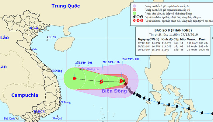
Location and movement of storm Phanfone.
Due to the influence of typhoon No. 8, in the area between the South China Sea and the southern sea area of the North China Sea, there is strong winds of wind level 8-10, the region near the center of the storm passed through strong level 11, level 13; ocean waves from 5-7m high; rough sea.
Dangerous areas in the South China Sea in the next 24 hours (wind radius of level 6, jerking from level 8 or higher) due to storms: From the parallel of latitude 12.5 degrees North latitude to 16.5 degrees North latitude ; east of meridian 113.5 degrees longitude.
Over the next 24 to 48 hours, the typhoon moved westward, traveling every 10-15km and weakening into a tropical depression, followed by a low pressure area. At 10 o'clock on December 29, the center of the low pressure area is about 15.1 degrees North; 111.0 degrees Kinh Dong, about 220km south from the Paracel Islands to the southwest. The wind in the center of the low pressure area drops below level 6 (below 40km / h).
In addition, due to the impact of strong cold air, from now until December 28 in the Tonkin Gulf and the offshore area from Quang Tri to Ca Mau, there is a strong northeast wind of grade 6, shock of level 8, rough sea; in the North of the South China Sea (including the Paracel Islands), there is a strong northeast wind of 6-7, level 9, strong sea.
Level of risk of natural disasters caused by storms: level 3.
- Phanfone, level 12, went to the East Sea
- Hurricane Phanfone engulfed Christmas Day in the Philippines in chaos