Co To Island and Bach Long Vi Island are affected by the storm No. 3
Due to the impact of typhoon No 3, Co To island station has strong winds of 15m / s (level 7), shocking 27m / s (level 10); At Bach Long Vi island station, there is a strong wind of 20m / s (level 8), shocking 24m / s (level 9).

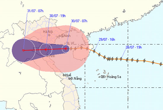
Direction of movement of the storm No. 3. Photo of the Central TechnicalDivision
At 07:00 on July 30, the location of the center of the storm was about 19.5 degrees north latitude; 107.9 Kinh Dong, about 230km from Thai Binh - Ha Tinh coast to the East. The strongest winds in the area near the storm center are strong at level 9, level 10 (ie from 89 to 102 km per hour), level 11 and level 12 jerks.
It is forecasted that in the next 12 hours, the storm will move mainly in the West, about 20 - 25km per hour. Thus, around noon (July 30), the storm will directly affect the provinces from Quang Ninh to Ha Tinh. By 16:00 on July 30, the location of the storm center was about 19.4 degrees north latitude; 105.5 Kinh Dong, in the North Central region. The strongest winds in the area near the storm center are strong at level 8, level 9 (ie 62 to 88 km per hour), level 10 and level 11 jerks.
In the next 12 to 24 hours, the storm continued to move in the West, about 20km per hour, going deep into the mainland and weakening into a low pressure area. By 07:00 on July 31, the central position of the low pressure area was about 19.3 degrees Vi Bac; 102.9 degrees Kinh Dong, in Central Laos. The strongest wind in the center of the low pressure area falls below level 6 (ie below 39km per hour).
Due to the impact of typhoons, there are strong winds of level 8 in the Gulf of Tonkin. The area near the center of the storm passes through level 9, level 10, shock level 11, level 12 and showers and strong thunderstorms. The sea is very strong. The coastal areas from Quang Ninh to Ha Tinh provinces will gradually increase to level 6, level 7, storm center level 8, level 9, level 10, level 11. Southern provinces in the North and North Central regions wind will gradually increase to level 6, there will be level 7, level 8 jerk. In the North and North Central region, there will be moderate rain, heavy rain, there are places with very big rain and scattered with thunderstorms. In a thunderstorm, there should be a tornado. The coastal areas of the provinces from Hai Phong to Nghe An need to watch for sea level rise in combination with high tide from 3 - 5m.
In addition, due to the influence of the southwest monsoon activity, in the middle and southern part of the South China Sea (including the Spratly waters), the waters from Binh Thuan to Ca Mau have strong winds of level 6. , level 7, level 8 jerks and showers and strong thunderstorms. The sea is rough. In a thunderstorm, there should be a tornado.
The next newsletter was broadcast at 11:30 on July 30.
News broadcast at: 09h30.
- Hurricane Kalmaegi caused strong winds of level 12 at Bach Long Vi island
- Warning: Storm No. 2 intensifies, Hanoi rains heavily this afternoon
- Tonight, typhoon Son Tinh attacked, many places at risk of flooding
- The last news about storm No. 3
- Storm No. 3 affects Nam Dinh and Thai Binh provinces
- Emergency response to hurricane Jebi
- Storm affected 50,000 boats and 80,000 people
- This afternoon, storm No. 10 landed in Ha Tinh - Quang Tri
- Hurricane number 9 with shock level 12 is 100km from Phu Quy island, the area of heavy rain is very affected
- Establishment of Bach Long Vi marine reserve
- Typhoon No. 7 in Quang Ninh, Hanoi in anticipation of wind gusts
- Influence of storm No. 7, Hanoi evening has heavy rain
 Is the magnetic North Pole shift dangerous to humanity?
 Washington legalizes the recycling of human bodies into fertilizer
 Lightning stone - the mysterious guest
 Stunned by the mysterious sunset, strange appearance