This afternoon, storm No. 10 landed in Ha Tinh - Quang Tri
Due to the influence of typhoon 10, at Ly Son island station, there was strong wind of 16m / s (level 7), shocking 22m / s (level 9); At Bach Long Vi island station, there is strong wind of 16m / s (level 7), shocking 21m / s (level 9) ; Hon Ngu island has strong winds of 13m / s (level 6), jerks 16 m / s (level 7); Con Co island has strong winds of 12m / s (level 6), shocking 22m / s (level 9). In the coastal areas of Thanh Hoa - Thua Thien Hue provinces, there are 6 - 7 winds.
>>>Super typhoon Wutip jerk level 17 is heading into the Central region
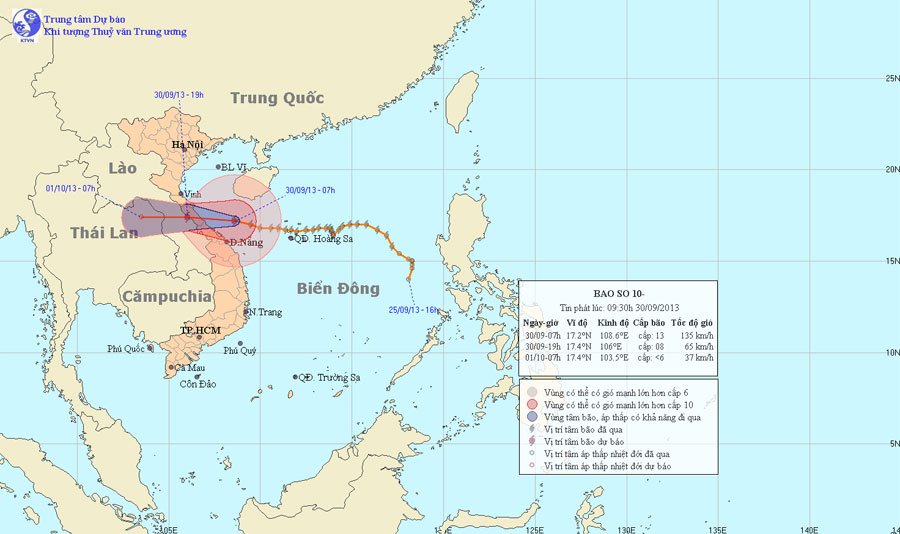
At 07:00 on September 30, the location of the storm center is about 17.2 degrees Vi Bac; 108.6 Kinh Dong, about 170km from the coast of Ha Tinh - Quang Tri provinces to the East. The strongest wind is in the area near the center of the storm with a strong level of 12, level 13 (ie from 118 to 149km per hour), level 15 and level 16 jerks.

Photo of the path and location of Typhoon Wupip
It is forecasted that in the next 12 hours, the storm will move in the direction of West and West Northwest, about 20km per hour. So around the afternoon and tonight (September 30), the storm center area is likely to go into the provinces of Ha Tinh - Quang Tri. By 19:00 on September 30, the location of the center of the storm was about 17.4 degrees Vi Bac; 106.0 Kinh Dong, on the border areas of Ha Tinh - Quang Tri - Laos provinces. The strongest winds in the area near the storm center are strong at level 8 (ie 62 to 74 km per hour), level 9 and level 10 jerks.
In the next 12 to 24 hours, the storm moved mainly in the West, about 20km per hour, going deep inland and weakening into tropical depression; then the tropical depression continued to move westward and weakened into a low pressure area. By 07:00 on October 1, the central position of the low pressure area is about 17.4 degrees Vi Bac; 103.5 degrees east longitude, on land in northeastern Thailand. The strongest wind in the center of the low pressure area falls below level 6 (ie below 39km per hour).
Due to the influence of typhoons, the waters of Quang Tri to Quang Nam and the Northern Gulf provinces have strong winds of level 9 - 10, the area near the storm center passes 11 - 13 levels, and level 15, level 16. Sea violently. North of Tonkin Gulf has strong winds of level 6-7, level 8, level 9. The sea is strong. The provinces from Thanh Hoa to Da Nang have strong winds of level 6-7, particularly the provinces from Nghe An to Thua Thien Hue have strong winds of level 8, level 9, the area near the storm center passes level 11, level 12, jerks level 14, level 15.
In the North and Central Central provinces, there is moderate rain, heavy rain. Coastal areas of provinces from Nghe An to Thua Thien Hue prevent sea level rise combined with tides of 3 - 4 meters high.
- The Storm of the Mountain Is Focusing on Central
- This evening, storm No. 5 landed on land from Quang Ngai to Khanh Hoa
- This afternoon and evening, the storm No. 4 will land in Ha Tinh - Quang Binh
- Low pressure to become a storm, landed in Ha Tinh - Quang Binh
- Storm No. 10 approached the land of Ha Tinh - Quang Binh
- Son Tinh storm swept through the Philippines, 6 people died
- Tin storm near the shore: Storm No. 3 appeared, heading to Da Nang - Quang Ngai
- Storm swept over 3 hours in Nghe An - Ha Tinh
- Podul storm landed in Quang Binh
- Beam of photos: The wild scenery where the storm No. 10 swept through
- Storm No. 8 weakens into a tropical depression
- Typhoon landed from Quang Ninh to Nam Dinh
 Is the magnetic North Pole shift dangerous to humanity?
 Washington legalizes the recycling of human bodies into fertilizer
 Lightning stone - the mysterious guest
 Stunned by the mysterious sunset, strange appearance