Typhoon Kammuri entered the South China Sea, becoming the 7th typhoon this year
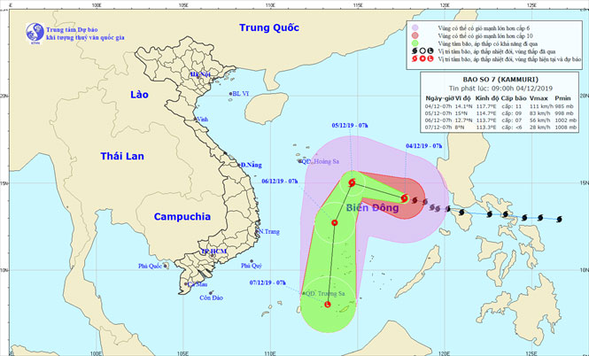
At 07:00 on December 4, the location of the storm center was about 14.1 degrees North; 117.7 degrees Kinh Dong, about 480km northeast of Song Tu Tay Island (Spratly Islands). The strongest wind near the center of strong storms level 10-11 (90-115km / hour), level 13. Strong wind radius from level 6, shock from level 8 or more about 250km from the center of the storm; Strong wind radius from level 10, level 12 or more shock about 100km from the center of the storm.
It is forecast that in the next 24 hours , the storm will move to the Northwestern direction, every hour it will be about 15km. By 07/12 on December 5, the location of the storm center was about 15.0 degrees Vi Bac; 114.7 degrees Kinh Dong, about 400 km north from Gemini West Island. The strongest wind near the center of strong storms level 8-9 (60-90km / h), level 11. Due to the impact of typhoons, the eastern sea area in the North and the middle of the East Sea has strong winds 8-9, the area near the center of the storm through level 10-11, level 13 shock; rough sea. Disaster risk level: level 3.

The position and direction of storm No. 7.
Dangerous areas in the East Sea in the next 24 hours (wind radius strong from level 6, jerking from level 8 or higher) due to storms' influence: from parallel 12.0 degrees North latitude to 16.5 degrees North latitude ; east of meridians 112.0 degrees Longitude.
Over the next 24 to 48 hours , the storm moved in a south-southwest direction, traveling every 10-15km and weakening into a tropical depression. At 07:00 on December 6, the location of the tropical depression was about 12.7 degrees North; 113.7 degrees Kinh Dong, about 160km from Song Tu Tay Island to the Northwest. The strongest wind near the center of strong tropical depression is level 7 (50-60km / h), level 10. The level of disaster risk: level 3.
Over the next 48 to 72 hours , tropical depressions move mainly to the South, each hour traveled 20-25km and weakened into a low pressure area.
In addition, due to the influence of the cold air was strengthened, from this afternoon to December 6 in the Tonkin Gulf, the northeast wind was stronger to level 6, sometimes level 7, level 8 shock; rough sea. The North and the middle of the East Sea (including the Paracel Islands), the western part of the South China Sea (including the West Sea of the Spratly Islands) strong northeast wind 6-7, jerky level 9; rough sea. The waters off the provinces from Quang Tri to Ca Mau have strong northeast winds of grade 6 and level 7; rough sea.
- Super typhoon Kammuri strikes the Philippines with winds of 200km / h
- Typhoon Kammuri hit the Philippines during the night, at least 1 person died
- Typhoon Linfa has entered the South China Sea
- Storm No. 13 could change direction, targeting Central
- Typhoon Tokage on the East Sea, in the South Central Coast
- Hurricane number 11 advanced quickly into the South China Sea
- Hurricane No. 2, level 10, entered the South China Sea on the days of Tet
- Haiyan storm left Vietnam, at least 13 people died
- Usagi super typhoon in the strongest year entered China
- Typhoon Soudelor entered Taiwan, the South China Sea has strong winds
- Typhoon Nida entered the South China Sea with 14-15 winds
- Haima storm causes level 16 wind to enter the South China Sea
- Super Typhoon Mangkhut jumped above level 17, accelerating into the South China Sea
- Super typhoon on level 17 is entering the South China Sea
 Is the magnetic North Pole shift dangerous to humanity?
 Washington legalizes the recycling of human bodies into fertilizer
 Lightning stone - the mysterious guest
 Stunned by the mysterious sunset, strange appearance