Typhoon Tokage on the East Sea, in the South Central Coast
This morning typhoon Tokage entered the South China Sea and became the No. 9 storm of the year, it is forecasted to head to the southern region of Vietnam.
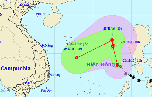
At 10 am on November 26, the storm was about 490 km northeast of Song Tu Tay Island (belonging to Truong Sa archipelago) with the strongest winds of 90 km / h, level 9 equivalent.

The planned path of Tokage follows the Central Meteorological and Hydrographic Forecast Center.(Photo: NCHMF).
In the north-northwest direction, the speed is about 10-15 km / h, on November 27, Tokage will be about 570 km from Hoang Sa archipelago to the east, the wind intensity will increase to 100km / h (level 10). The danger zone for ships is from the 13.0 latitude North to 18.0 degrees North latitude; eastern meridian 116.0 degrees Kinh Dong.
On November 28, the storm was about 560 km east of Hoang Sa archipelago to the east, the intensity of wind level 9. After that, the typhoon could break down in the west and southwest, towards the South Central of Vietnam.
The meteorological warning and circulation agency after the storm combined with the cold air strengthened on November 29 will cause rain for Da Nang - Khanh Hoa from November 30 to December 2 with the amount of up to 200-400 mm. On rivers in this area, there is a possibility of flooding with flash flood risk and landslide. Then the rain shifted to the North (Nghe An - Thua Thien Hue).

Hong Kong meteorological station predicts the number 9 storm toward Vietnam.(Photo: HKO).
Today, the Central Steering Committee for Disaster Prevention and Control has sent electricity to the coastal provinces of Quang Ninh - Ba Ria Vung Tau, asking the localities to monitor the evolution of the storm, proactively informing the means of operation. on the sea does not enter the dangerous area; tally boats and direct safe anchorage.
Localities also need to monitor water level changes in rivers and streams and reservoirs.
- Typhoon Tokage jerked level 10-11 toward the East Sea
- Storm No. 1 entered the Central Coast
- Typhoon Krosa threatens the Central
- Super typhoon Haiyan is about to land in Philippines
- Typhoon Tembin made landfall in South Korea causing much damage
- Hurricane No. 2, level 10, entered the South China Sea on the days of Tet
- Storm Nalgae heads straight to North Central
- Strong tropical depression into storm No. 1 (Typhoon Bolaven), toward the South Central
- Super typhoon on level 17 is entering the South China Sea
- Storm No. 2 is about 590 km from the coast of Quang Ninh and Hai Phong
- This afternoon, the new low pressure is close to South Central and South
- Storm No. 6 weakened, heavy rain in Thanh Hoa - Quang Nam
 Is the magnetic North Pole shift dangerous to humanity?
 Washington legalizes the recycling of human bodies into fertilizer
 Lightning stone - the mysterious guest
 Stunned by the mysterious sunset, strange appearance