Self-charging robot maps the seabed, the last frontier of the Earth
Over the centuries, humans have explored countless mountains, forests, and deserts. However, what covers more than 70% of the Earth's area is the ocean is still a great mystery to us. In fact, we know more about the surface of Mars than we know about the oceans on Earth. Currently, we have only explored about 20% of the ocean's area.
Having a big picture of the ocean helps us navigate safer ships, create more climate patterns, lay underground cables, build wind farms along the coast, and protect wildlife. marine animals – all of which is part of a project called the 'sea economy' worth 3 million billion USD by 2030.

Having a bird's-eye view of the ocean helps us navigate our ships more safely.
Automated robots are equipped with sensors that allow for faster data collection and lower costs than ever before. But many of these vehicles are battery-operated and have limited lifespans, requiring them to return to a ship or shore to recharge. Therefore, the use of these means is quite difficult in the offshore waters.
Seatrec , a 5-year-old start-up founded by oceanographer Yi Chao, has taken on this challenge. Speaking to CNN, Mr. Chao said while working for NASA, he developed charging technology for marine robots by taking advantage of the ocean's 'natural temperature changes' .
Greener – cheaper
Power supplies can be installed on data-collecting robots, or on Seatrec ships , and they can use sonar systems to map their surroundings. After that, the robot will return to the sea surface and send data to the center via satellite.

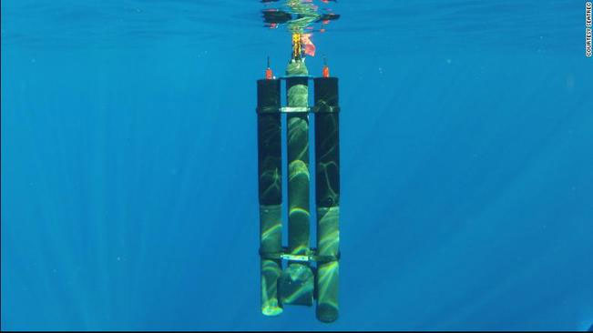
Seatrec's ship uses the ocean's temperature variation to generate active energy. (Photo: CNN).
As the ship moves between the cold and warm waters of the ocean, the material inside the energy system will melt or freeze, create pressure, and then convert it into heat and generate electricity for the robot to operate. .
"They are charged by the ocean, so their operating time is extended almost indefinitely ," Chao said.
Each research vessel with basic equipment costs about $20,000. Installing more of Seatrec's energy system will cost about $25,000 more, Chao said.
But in return, access to free renewable energy and the ability to stay at sea longer, delivers massive amounts of data at a cost 5 times cheaper on a long voyage, Mr. Chao shared.
He said that each year, his start-up produces less than 100 sets of equipment, mainly for marine research projects, but the technology can be completely scaled up. The Seatrec power generation system can also be retrofitted onto existing mapping equipment to extend their range.
Speeding
According to Jamie McMichael-Phillips, director of the Nippon Foundation-GEBCO Seabed 2030 Project, the new technology could help data collection devices reach remote areas in the middle of the ocean to draw maps.
"One of the big challenges we face is simply physics ," said McMaichael-Phillips. 'When mapping land we can use cameras [or] satellites, but with oceans, light cannot penetrate the water column. So the use of sonar systems is very limited'.
The Seabed 2030 Project, implemented since 2017, helps raise awareness of the importance of the seabed, and sets clear goals for researchers and companies in the field to aim for: completing seafloor map by the end of the decade.
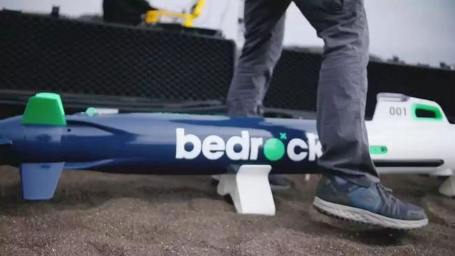
Some companies, like XOCEAN, do ocean exploration from the surface. Another start-up, Bedrock Ocean Exploration, says it can complete seabed surveys up to 10 times faster than traditional methods by using autonomous electric submarines with sonar systems, camera and laser; The data is then analyzed on Bedrock's cloud platform.

Bedrock Ocean Exploration uses an autonomous electric submarine with sonar, camera and laser systems. (Photo: CNN).
Challenges ahead
Despite the growing number of technologies for mapping the seafloor, the completion of this map still presents other logistical and financial challenges.
Mr. Chao estimates that about 3,000 Seatrec ships will need to operate in the next 10 years to be able to survey the entire ocean. Seatrec has also raised an investment of $2 million to expand its energy system production.
However, this is only a small amount of capital to be able to explore the entire ocean. It is estimated that the survey "would require somewhere between $3 and $5 billion," said McMicheal-Phillips -- "about the same amount of money needed to launch a Mars mission."
DiMare, from Bedrock, believes it's time to invest in the planet we live on.
'If we want to continue to keep Earth a habitable place, we need to be more understanding of what's going on on this planet,' he said.
- Canada started drawing seabed maps around the North Pole
- Seabed exploration robot
- South Korea deploys a state-of-the-art frontier robot team
- The earth may be 'scorched' because of heat after 85 years
- How does wireless charging work?
- How to see the Moon, Mars with Google Maps
- 5 charging habits are causing the iPhone to crash faster
- Nokia is developing battery technology without charging?
- Wireless charging to charge the whole car is running
- The car itself charging
- Global wind map
- The oldest map in the world sells for 8.5 billion
 The US company is about to build a supersonic passenger plane of 6,000km / h
 Japan develops avatar robot as in fiction film
 Australia tested the world's first mango picking robot
 America develops technology to separate water from animal waste
 Why is finding a missing submarine in the ocean like 'looking for a needle in a haystack'?
  Piercing submarines and daring to fight humans: How did this creature, once as small as a grain of rice, do it?
  Where the world's oceans meet
  Hurricane Dora makes history with its bizarre path across the ocean, from the Americas to near Asia
  NASA robot captures 'living ocean' on Mars
  Do aquatic animals pee?