Super storm Meranti moves quickly into the East Sea
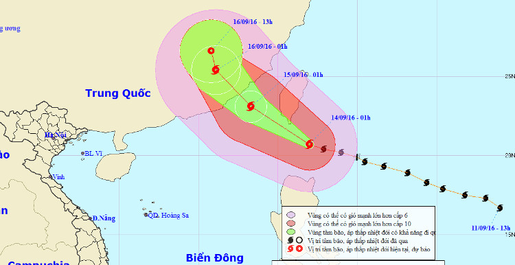
The Center for Meteorological and Hydrological Forecasting said that at 1 hour today (September 14), the location of the center of the storm is about 20.7 degrees Vi Bac; 122.0 degrees Kinh Dong, about 260km from Lu Dong Island to the North. The strongest wind in the area near the center of strong storm level 17 (200-220km / hour), jerking on level 17.
It is forecasted that in the next 24 hours , the storm will move west and northwest, about 20km per hour. By 01:00 on September 15, the location of the storm center was about 23.1 degrees North latitude; 118.3 degrees east longitude, on the northeast sea of the East Sea. The strongest wind in the area near the center of the storm is strong level 16 (185-200km / hour), jerking on level 17.

Location and forecast of the path of super typhoon Meranti.(Source: Central Center for Hydrometeorological Forecasting).
Due to the impact of the storm, the East Sea in the East Sea has strong winds of level 10-14, the area near the center of the storm passes level 15-17, jerks at level 17. The sea is fierce.
In the next 24 to 48 hours, the storm is capable of changing the direction of travel in the Northwest direction, about 15km per hour. By 01:00 on September 16, the location of the storm center is about 25.4 degrees Vi Bac; 116.1 degrees east longitude, on the mainland southeast of Guangdong province (China). The strongest wind is in the area near the center of strong storm level 10 (90-100km / hour), level 13 jerks.
Due to the impact of the storm, the East Sea in the East Sea has strong winds of level 10-13, the area near the center of the storm passes through the level of 14-16, jerks at level 17. The sea is rough.
In the next 48 to 72 hours , the storm has the ability to change the direction of travel in the north-northwest direction, about 10km per hour.
- Super storm Meranti landed, Taiwan was deserted
- Super typhoon on level 17 is entering the South China Sea
- Hurricane Kalmaegi moves at a very fast speed
- Noul storm does not enter the South China Sea
- Hurricane No. 3 moves quickly, landing in provinces from Thai Binh to Ha Tinh
- 2 super typhoons followed each other into the South China Sea
- A strong storm of level 14 appeared in the South China Sea
- Podul storm into the East Sea, the wind 60-75km / h
- Super typhoon Mangkhut is on a par with the super typhoon Haiyan
- Aere storm entered the South China Sea
- Hurricane Koppu turned to the north
- Influence of super typhoon, East Sea is about to have strong winds
 Is the magnetic North Pole shift dangerous to humanity?
 Washington legalizes the recycling of human bodies into fertilizer
 Lightning stone - the mysterious guest
 Stunned by the mysterious sunset, strange appearance