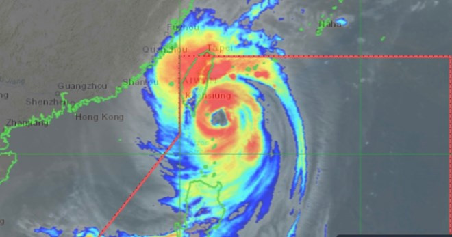
Super typhoon Kong-rey causes fear with giant storm eye
Super Typhoon Kong-rey has one of the largest eyewalls ever recorded in the history of storms on Earth, "absolutely gigantic".
Newsweek's latest storm report says a storm expert has expressed horror at the size of the eye of super typhoon Kong-rey as it approaches Taiwan (China).

Location of super typhoon Kong-rey on the morning of October 31. (Photo: PAGASA).
Commenting on the size of Kong-rey's eye, meteorologist Noah Bergren of WOFL television in Orlando, Florida, noted : "Super Typhoon Kong-rey easily has one of the largest eyewalls of a major tropical system ever observed on Earth. It's absolutely massive . "
Having a large eye doesn't necessarily mean a storm will be stronger, said AccuWeather senior meteorologist Alan Reppert . " A large eye means the winds are blowing farther out from the center of the storm than if the eye were smaller, " he said. A strong storm that has existed for a long time will typically have a wider eye than a newly formed storm, he added.
Most models predicting the potential path of Super Typhoon Kong-rey suggest that the storm will make landfall on the southeastern coast of Taiwan (China ) and cut across the island before heading out to sea. The storm will then turn northeast, away from China and out into the East China Sea.
The New York Times noted that the intensity of super typhoon Kong-rey is atypical of storms that occur at this time of year during the hurricane season, and predicted that Kong-rey would make landfall as a Category 4 storm on the Saffir–Simpson hurricane scale.
AccuWeather expert Alan Reppert warned that winds of up to 225 km/h, with stronger gusts, could occur in southern Taiwan (China) although Kong-rey is forecast to weaken as it passes the island.
AccuWeather's typhoon forecast warns of significant structural damage and landslides from Typhoon Kong-rey as up to 914 mm of rain is expected in Taiwan. The storm could maintain its intensity or strengthen before making landfall today (October 31) .
Heavy rain is also expected in eastern China and Japan on the path of super typhoon Kong-rey .
According to the latest storm news at 5:00 a.m. on October 31 from the Philippine weather agency updating the developments of super typhoon Kong-rey (local name is Leon), severe weather conditions are expected in the Northern Luzon area, Philippines as the super typhoon near the East Sea moves near Batanes.

Typhoon Kong-rey is forecast to reach its peak and make landfall today (October 31). (Photo: PAGASA)
The center of Super Typhoon Kong-rey is located 100 kilometers northeast of Itbayat, Batanes. The storm is moving northwest at 20 kilometers per hour with maximum sustained winds of 195 kilometers per hour near the center and gusts of up to 240 kilometers per hour.
PAGASA forecasters said that Super Typhoon Kong-rey will reach its peak intensity when it gets closest to Batanes in the next 3 hours but is currently unlikely to make landfall in the area. Kong-rey will make its first landfall on the east coast of Taiwan (China) this afternoon. PAGASA also did not rule out the possibility of the typhoon making a second landfall in mainland China in the coming time on November 1.
Super Typhoon Kong-rey is forecast to weaken into a typhoon in the next 12 hours before making landfall in Taiwan. Interaction with the island's mountainous terrain will result in continued weakening of Kong-rey for the remainder of the forecast period.
- Typhoon Kong-rey appears off the coast of the Philippines, unpredictable developments, new landfall location forecast
- Usagi storm is rushing into Hong Kong gateway
- The 10 biggest storms recorded in history
- Typhoon Mangkhut landed Hong Kong with each wave as high as 14m
- Adding super typhoon 240km / hour winds to Japan and Taiwan
- Super storm Neoguri looks from the universe
- Big storms destroy the world
- Typhoon Nida entered the South China Sea with 14-15 winds
- Super storm Meranti landed, Taiwan was deserted
- Typhoon Haiyan is heading into Quang Ngai
- Super strong storm has avoided Vietnam
- Typhoon Vicente hit Hong Kong, more than 100 people were injured
 Is the magnetic North Pole shift dangerous to humanity?
 Washington legalizes the recycling of human bodies into fertilizer
 Lightning stone - the mysterious guest
 Stunned by the mysterious sunset, strange appearance