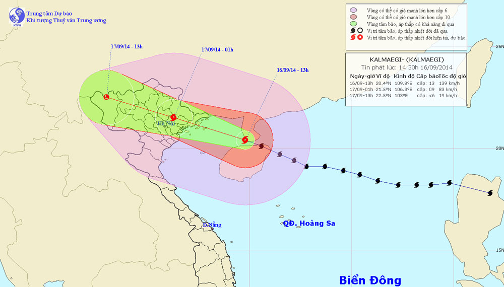
Typhoon Kalmaegi crossed Hainan Island and entered the waters of the Gulf of Tonkin
This afternoon (September 16), Typhoon 3 crossed the northern island of Hainan (China) into the North Sea of Tonkin Gulf.
Currently, typhoons have affected coastal areas from Quang Ninh to Nam Dinh, causing strong winds of 7-9; In Bach Long Vi island, there was strong wind level 8, level 9 shock, Co To island had strong level 6 wind, level 8 jerk.
At 13 o'clock , the location of the center of the storm is about 20.4 degrees north latitude; 109.8 degrees east longitude, about 320km from Hai Phong - Quang Ninh coastline to the East of Southeast. The strongest wind is in the area near the center of the storm with a strong level of 12, level 13 (ie from 118 to 149km per hour), level 15 and level 16 jerks.

Photo of the path and location of Typhoon Kalmaegi
It is forecasted that in the next 12 hours , the storm will move in the West-Northwest direction, about 25-30km per hour. In the Gulf of Tonkin, there are strong winds of level 8-9, particularly in the Northern Gulf of Tonkin (including the districts of Bach Long Vy, Co To, Van Don and Cat Hai), grades 10-11, the area near the center of the storm passes level 12 - 13, level 15 - 16 jerks, ocean waves 5 - 6m high. The sea was fierce.
This night, the center of the storm will enter the mainland of the eastern provinces of the North, the strongest wind in the area near the center of the storm is strong at level 10 and level 11, then the storm goes deep inland and weakens further. By 01:00 on September 17, the location of the center of the storm was about 21.5 degrees North latitude; 106.3 degrees Kinh Dong, on the mainland of the Northern Northern provinces. The strongest wind in the area near the storm center is strong at level 9 (ie from 75 to 88km per hour), level 10 and level 11. In the coastal provinces from Quang Ninh to Nam Dinh and Lang Son and Bac Giang provinces, Hai Duong has strong winds of level 8-9, the area near the center of the storm passes from level 10 to 11, level 12 to 13. The other places in the North East have strong winds of level 6-7, level 8 shock. Now in the North, there is a moderate rain, heavy rain, particularly in the Northeast and mountainous areas in the North, there is a heavy rain.
In the next 12 to 24 hours , the storm moved west-northwest, about 25 - 30 km per hour, continued to go deep into the soil and weakened into tropical depression and then a low pressure area. . By 13:00 on September 17, the central position of the low pressure area was about 22.5 degrees North latitude; 103.0 degrees east longitude, on the mountainous area in the northwest. The strongest wind in the center of the low pressure area falls below level 6 (ie less than 39km per hour). In the Northern provinces (including the Northwest) continue to have moderate rain, heavy rain to very large.
- 19h tonight, the storm center is located on the waters of Quang Ninh - Hai Phong
- Hurricane Kalmaegi moves at a very fast speed
- Storm No. 4 increased to level 11, entering the Gulf of Tonkin
- Hurricane Kalmaegi caused strong winds of level 12 at Bach Long Vi island
- Emergency response to hurricane Jebi
- Typhoon Sarika will land in Vietnam
- Hurricane 6 suddenly turned, headed into the Gulf of Tonkin
- New storm appeared on the East Sea
- Typhoon Kalmaegi has entered the South China Sea, the country has scattered rain
- Hurricane Kalmaegi is level 13, going straight to the waters of Quang Ninh - Hai Phong
- Typhoon Kalmaegi entered the South China Sea, possibly landing in Quang Ninh - Hai Phong
- Utor storm tomorrow causes strong winds of 100km / h in the Gulf of Tonkin
 Is the magnetic North Pole shift dangerous to humanity?
 Washington legalizes the recycling of human bodies into fertilizer
 Lightning stone - the mysterious guest
 Stunned by the mysterious sunset, strange appearance
 Super typhoon Manyi enters the East Sea, cold air moves slowly
  Storm No. 9 Manyi, level 12, about 200km from Hoang Sa archipelago
  Storm Tra Mi enters the East Sea today, strange movement direction
  The Da River fault zone causes earthquakes in Ninh Binh
  Sea levels are rising rapidly due to El Nino and climate change
  Tropical depressions appear into the East Sea, likely to become a typhoon