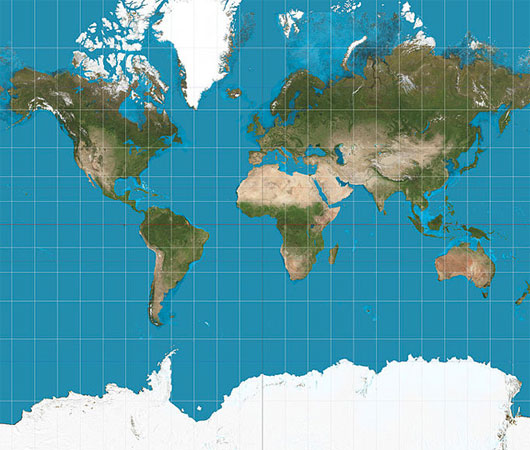
Why are all the current world maps wrong?
In any current world map, Africa, China and Alaska are distorted, despite the availability of accurate satellite data. This phenomenon stems from the biggest challenge for mapping experts: it is impossible to portray the true, spherical world on a flat map.
Looking at today's world maps, you are more likely to see North America than Africa, Alaska "bigger" than Mexico and China smaller than Greenland. However, in fact, China is four times larger than Greenland, Africa is three times bigger than North America and Mexico "more" than Alaska.
The distortion is the result of Mercator projection , the most popular map used to hang on the classroom wall or print in textbooks. The Mercator projection map was born in 1956 to help sailors sail ships around the world.

The map that uses the most popular Mercator projection today in textbooks and schools distorts the size of China, Africa and Alaska.
According to experts, the biggest challenge is that it is impossible to accurately describe the spherical world on a flat map - the problem that haunts cartographers for centuries. Therefore, the shape of the world maps was very rich, from heart shape to cone. However, the difference gradually disappeared with the superior map model invented by Gerardus Mercator.
The familiar Mercator projection provides the right shape of the lands, but at the cost of distorting their size, favoring the rich lands in the north.
You may think, the appearance of satellite images and tools like Google Maps have improved our vision of the world. However, the truth is not that, according to writer James Wan of Guardian magazine. According to Wan, most of this is due to technical reasons, while other distortions are caused by ideology, changing the way we view the world.
In 2005, the Google Earth utility program demonstrated the world with areas most interested by users in a central location and included in any content that we consider important. For the first time, the ability to create an accurate map has been put in everyone's hands, and it has changed the way we view the world. However, it also has the disadvantage that there are few uniform standards for content that need to be added to the map, and areas that are less populated or "less important" are ignored.
Today, there are millions of visits to Google Maps every day, helping us navigate the way, observing streets, towns and countries. Google Maps claims to be in "never-ending conquest to have a perfect map".
Jerry Brotton, a map research historian and author of "A History of the World in Twelve Maps" , is skeptical of this. He argues that every map is age-old and serves certain purposes.
World Map Template

- The oldest map in the world sells for 8.5 billion
- How to see the Moon, Mars with Google Maps
- Global wind map
- All previous world maps were completely wrong, this is the correct map
- How does Google Maps work?
- Mysterious places on Google Maps
- How to use Google Maps where there is no Internet
- Google Maps complements the Moon map and many other planets
- Explore the world through 15 incredibly interesting maps
- Interesting maps of the world around us
- Language map of the world
- The world's first crop map from satellite imagery
 'Fine laughs' - Scary and painful torture in ancient times
 The sequence of numbers 142857 of the Egyptian pyramids is known as the strangest number in the world - Why?
 History of the iron
 What is alum?