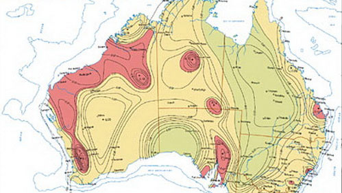
Australia announced earthquake map
Australian researchers have just developed a series of maps that provide new information about the earthquake-prone areas in the country. Map published by the Australian Ministry of Natural Resources and Energy today November 19.

An Australian earthquake hazard map - (Photo: smh.com.au)
Called 'Map of Australian earthquake risk areas' , this map was built following detailed studies of earthquakes in Australia in the past. According to Energy and Energy Minister Martin Ferguson, this is a map of earthquake risk assessments across Australia and forecast areas of earthquakes.
It is expected that this information will be aggregated into the construction field, helping engineers design buildings that can withstand strong earthquakes.
'These data can also be made publicly available to emergency managers, urban planners, researchers . so they can conduct a more detailed analysis ,' said Minister Ferguson. know in a statement.
From 1950, there were 168 earthquakes in Australia with magnitudes greater than 5 Richter. In 2011, the country recorded 82 earthquakes with magnitudes of 3 or more.
- Earthquake is 6 degrees off Australia
- Indonesia: A series of aftershocks after an earthquake of 7.8 Richter scale
- Mysterious city is earthquake more than 30 times / month
- Earthquake in Ecuador: The number of people killed is up to 413
- New Zealand was pushed to Australia after an earthquake
- Japan was again shaken by the second earthquake
- 3.3 degree earthquake in Bac Tra My
- Tokyo shakes because of the earthquake
- Italy shook again because of the earthquake
- A 60m high 'destructive' tsunami could hit Australia
- Chile shook by a powerful earthquake
- Nicaragua has strong earthquakes, spreading to many neighboring countries
 Is the magnetic North Pole shift dangerous to humanity?
 Washington legalizes the recycling of human bodies into fertilizer
 Lightning stone - the mysterious guest
 Stunned by the mysterious sunset, strange appearance