NASA: We are experiencing the peak of El Nino
NASA's Earth Observatory has made a remarkable statement about the El Niño phenomenon. The present time is confirmed to have reached the climax of the phenomenon of abnormal temperatures outside the Pacific.
Accordingly, NASA said the water temperature in Pacific waters will return to a more moderate level this summer. But this will be the premise for the re- emergence of La Niña phenomenon which is expected to have a 40% chance of appearing at the end of 2016. The typical effect of La Niña phenomenon will be storms on the sea. Atlantic Ocean but frequency is less than in Pacific Ocean.

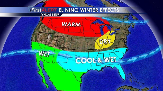
Many states in the southeastern United States had to declare a state of emergency caused by snow storms.
However, NASA is not really sure about the evolution of El Niño at the present time. This may be due to global warming and record high temperatures over the past 135 years are not yet the end of the most powerful cycle of El Niño ever.
According to researchers from the US Oceanic and Atmospheric Administration (NOAA), the seawater temperature in the Niño 3.4 area in the Pacific Ocean - which is often the El Niño center every year - has just broken the record of the month. 12/2015. The average surface water temperature in January 2016 was 2.38 degrees C higher than the normal threshold and exceeded 0.14 degrees Celsius compared to the record of December 1997 of 2.24 degrees Celsius. Particularly in December 2015, the three-month average temperature in Niño 3.4 recorded similarities with the record high temperature during the same period in 1997.

The chart of abnormal height difference of sea level (mm unit) with red is higher and blue is lower between January 2015 (left) and January 2016 (right).
The map data compares the height of the Pacific sea level abnormality measured by NASA on January 17, 2015, before the El Niño phenomenon. According to the latest data collected on January 18 through Jason-2 satellite, the anomaly of the average height of sea level has changed dramatically.
The red blocks represent the sea level higher than the average. It also means that there is a warmer water around the place. Meanwhile, the blue block represents places with sea level and lower temperature than average. Normal sea level conditions are expressed by bright white areas.
In an update on January 14, NOAA's climate forecasting service said: "A strong El Niño wave continues to happen in December 2015 with sea surface temperatures across the central region and Eastern Pacific equatorial . El Niño has caused significant impacts on all global weather patterns, the phenomenon is expected to affect temperature and rainfall throughout the United States during the months. forthcoming . Most climate models show that the strength of El Niño will undermine the transition rate to the ENSO neutral weather model, which takes place at the end of spring or early summer " .

Comparison of sea level abnormality by month from January 2015 - January 2016.
ENSO stands for El Niño and La Niña phenomena combined with the atmosphere (SO). Because these two Pacific equatorial weather events are closely related, they are linked into a dual phenomenon called ENSO.
Oceanographer Tony Busalacchi of the University of Maryland (USA) notes that the normal El Niño-affected weather rainfall will be similar to the weather pattern once recorded in the period 1997 - 1998 or 1982. - 1983. The most obvious example is that South America has a record of cold and wet winters. The Pacific Northwest has recorded rain and snow storms. On the other side of the Pacific Ocean, specifically Indonesia, received the dry weather. This year El Niño has become a century event similar to the period between 1997 - 1998.

According to US officials, about 19 people have been killed in a record snowstorm on the East Coast of the United States.(Photo Dailymail).
Bill Patzert, a climatologist at NASA's Jet Propulsion Laboratory, found that this El Niño phase will likely continue to "peak" once more. Patzert points out that trade winds and the strong activity of the west wind trench can be an abundant source of energy to nourish warming in the eastern Pacific Ocean. And certainly, February or March of this year will still see the negative effects of the El Niño phenomenon on the planet.
El Niño is an unusual warming phenomenon of seawater in the equatorial belt with a range stretching nearly 10,000km, from the South American coast to the Marshall Islands in the mid-Pacific region. The El-Nino phenomenon is associated with the unusual occurrence of warm ocean currents in the eastern Pacific Ocean, causing a global climate change.
- El Nino 2015 looks strange with the peak of 1997
- Can 2015 El Nino cause more natural disasters?
- NASA misplaced Everest on India
- El Nino changes may cause many storms to land
- Nature is angry, El Nino will be more intense
- The origin of the term El nino
- El Nino can last until May 2010
- El Nino is coming back
- The North is about to enter the peak of the winter cold
- Frost appears on Fansipan peak
- El Nino is about to end in the Caribbean
- El Nino may stop working in the middle of this year
 Is the magnetic North Pole shift dangerous to humanity?
 Washington legalizes the recycling of human bodies into fertilizer
 Lightning stone - the mysterious guest
 Stunned by the mysterious sunset, strange appearance