Storm No. 8 - the most bizarre storm ever
' In the history of our country's meteorological and hydrological history, this is probably the most dramatic storm ,' said Dr. Bui Minh Tang, Director of the Northern Delta Hydrometeorological Station.
Update the storm news number 8 in 2016: Super typhoon Haima jumped above level 17, moving quickly into the South China Sea
Update storm news number 7 in 2016: Storm No. 7 into Quang Ninh, Hanoi to prevent wind gusts
 Hydrometeorological experts agreed that the No. 8 typhoon had just landed in Vietnam and named Kai-Tak, an old airport in Hong Kong, the most bizarre storm ever.
The expert in charge of the weather program on CNN TV on November 2 must also say: ' This is a storm with a strange path and happenings '.
When newly formed in the East Sea as a tropical depression early in the morning of October 28, the intensity was only at level 6, level 7, it did not have any abnormalities. Just one day later, he began to testify. For the first time in its history, right in the South China Sea, it jumped to level 12 within two days instead of taking at least 3-4 days as a rule. At noon on October 29, the wind intensity increased to level 10. At the beginning of October 31, it increased to level 12, jerked on level 12.
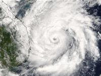
Photographs from a medium resolution spectrophotometer (MODIS) on Terra satellites show that Vietnam's storm No. 8 and number 22 in the Western Pacific sometimes reach a wind speed of 140 km / hr. near the storm center, above level 12, at 10: 10 minutes on October 31 (photo).
Normally when traveling in the West-Northwest direction, strong storms move steadily and quickly go ashore. But typhoon No. 8 upset everything, "said Dr. Nguyen Lan Chau, deputy director of the Central Hydrometeorological Center.
' 230 km from Quang Ngai coast, we think the storm will land here. Somehow, it immediately turned to Da Nang '- Dr. Chau recalled -' If I thought about landing in Quang Nam, Da Nang, the storm would change direction along the coast '.
Another point that makes scientists especially aware that, when the intensity is strong, storms often move quickly. But typhoon 8 did the opposite. The stronger the intensity, the faster the speed of movement is. On average, this storm only moves 5-10 km / hour, sometimes it seems to stand still. ' Very few strong storms are moving so slowly ' - Thao expressed surprise.
During the period from 28 to 29 October, a northeast monsoon occurred and affected the North, North Central and Central Central. This monsoon climate causes the temperature background to drop 4-5 degrees Celsius. The intensity of the storm should be reduced when interacting with such a cold wind font. Yet it behaves against the rules. By the time it weakens, it behaves with unexpected speed. Within 24 hours, from level 12 'collapsed' into a tropical depression in a confusing way.
Most hydro-meteorological experts are also stunned to see that the road along the coast of the storm almost coincides with the coastline in our country. According to engineer Thao, ' Storm No. 8 is an amazing phenomenon, worthy of the most special ranking in the 1950s and beyond '.
In 1986, the storm No. 5 appeared in the South China Sea, moved near the shore, then returned to the South China Sea, went out and entered the South China Sea three times, creating an extremely complicated movement.
In 1995, a typhoon moved parallel to the coastline, but it was quite far from the coast (the 8th year typhoon also goes parallel to the coast but is very close to the coast). Guangxi, China caused 13 provinces of China to rain.
- Tin latest storm No. 3: Lightning storms landed in Hai Phong - Ninh Binh
- Storm No. 15 has not melted, near the East Sea, a new storm appears
- Tropical depression strengthened into storm No. 2, heading to Quang Ninh - Hai Phong
- 8 incredible bizarre animals exist in the world
- Storm Dianmu accelerated, Hanoi prepared to catch a storm
- Why is storm No. 10 the first storm in Vietnam to be warned red?
- Standing still for 24 hours, storm No. 4 is about to accelerate
- Cyclone storm, typhoon typhoon and storm tropical storm What's the difference?
- A strong storm of level 14 appeared in the South China Sea
- Storm No. 10 approached the land of Ha Tinh - Quang Binh
- A new storm appeared on the east sea, storm Pakhar
- The strange giant cloud appears in the sky of Sydney
 Is the magnetic North Pole shift dangerous to humanity?
 Washington legalizes the recycling of human bodies into fertilizer
 Lightning stone - the mysterious guest
 Stunned by the mysterious sunset, strange appearance