Entering the East Sea on the night of October 18, Megi storm strengthened to level 15, increasing one level. Hoang Sa area, where the storm swept through, there are many Vietnamese fishing boats.
The central hydro-meteorological center said that at 7 am this morning, the center of the storm in the east of the East Sea, the intensity of 14-15 level, is about 150-183 km per hour.
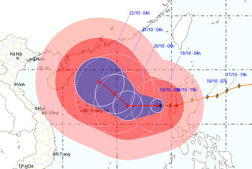
Forecast day and tonight, Megi in the west, speed 10-15 km per hour. By 7:00 pm on October 20, the storm center was about 400 km east of the Paracel Islands to the east, the intensity reached level 14-15. After that, the storm rolled up north in the direction between west and northwest and northwest, speed 10 km per hour, strong level 15.

Predict the path and area of the storm of Vietnam station. (Photo: NCHMF).
Because of the super typhoon, Megi's area of influence is very wide. From the center of the storm, the dangerous strong wind zone from level 10 or higher has a radius of about 200 km, from level 6 or higher has a radius of about 400 km.
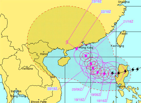
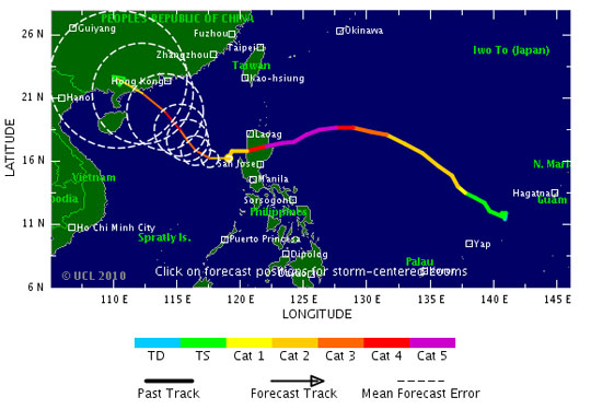
Currently, the position and time of storms landed, Vietnam radio station has not forecasted. International stations such as the US Navy, TSR of the University of London or the Japanese radio all believe that the storm will go between China and Hong Kong Island of China. The landing time is forecast by the US Navy station on the night of October 22.
On the way to move, the storm causes strong winds of level 11-12 for the area east of the East Sea, the area near the center of the storm going through the wind will be strong at level of 14-15, high waves of 12-14 m, the sea is rough. From the night of Hoang Sa archipelago sea wind will gradually increase from level 8 to 11, the area near the center of strong storm level 12-13.
Meanwhile, according to the National Committee for Search and Rescue, in Hoang Sa area there are 12 ships with 174 fishermen in Quang Ngai, of which 3 ships are on the way back to Ly Son Island. In addition, in the Truong Sa archipelago area, there are more than 350 ships with nearly 4,000 fishermen operating.

Predict the route and landing area of the US Navy station. (Photo: Vnbaolut.com).
At the emergency meeting yesterday, Deputy Prime Minister Hoang Trung Hai directed the coastal provinces from Quang Ninh to Khanh Hoa to be ready to deal with the possibility of landfall and intensity level 16.
In the public electricity right after the meeting, the Deputy Prime Minister asked the provinces to insist on calling boats offshore fishing for safe storm shelter, especially those operating in the Paracel Islands and the northern region, between the East Sea.
Localities should have plans to store food and foodstuffs in critical areas, at risk of being divided during floods and storms; plan to fight against houses, warehouses, schools, hospitals, for students to leave school before the storm hits .

As the strongest storm in the Pacific for the past 20 years , when it hit the Philippines yesterday with level 14, typhoon Megi killed at least 10 people, more than 3,000 people had to evacuate.
In Vietnam, the most powerful storm that landed in the last 10 years was Xangsane in 2006. With level 13, the typhoon caused more than 60 deaths, more than 200,000 houses collapsed and roof speed, nearly 800 ships sunk, damaged. Total estimated damage is at least VND 10,000 billion. Damage of Danang is up to 5,300 billion VND. According to the calculation of the leader of Da Nang city, the typhoon pulled back the development speed of the city for 10 years.
[#RelatedNews (10) #]
 Is the magnetic North Pole shift dangerous to humanity?
 Washington legalizes the recycling of human bodies into fertilizer
 Lightning stone - the mysterious guest
 Stunned by the mysterious sunset, strange appearance