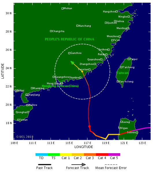
According to the Central Hydrometeorological Forecast Center, on October 23, the storm No. 6 (Megi) will land in the coastal area of Hong Kong (China) with the strongest wind in the area near the center of strong storms. level 15, level 16, level 17 jerk.

The direction of super typhoon Megi. (Tropicalstormrisk photo)
At 4 o'clock on October 20, the position of the center of storm No. 6 on the eastern area of the East Sea, about 550km from the Paracel Islands to the East.
The strongest wind is in the area near strong storm level 14, level 15 (ie from 150 to 183km per hour), level 16, level 17.
It is forecasted that in the next 24 hours, the storm will move in the direction between West and Northwest and about 10km per hour.
At 4 o'clock on October 21, the location of the storm center is about 430 km northeast of the Hoang Sa archipelago. The strongest wind level is near the storm center with level 15, level 16, level 17.
From the center of the storm, the dangerous strong wind zone from level 10 or higher has a radius of about 200km, from level 6 or higher has a radius of about 400km.
Due to the impact of storms, the East Sea in the East Sea has strong winds of level 11, level 12, the area near the center of the storm passes through level 14, level 15, level 17. The sea waves are from 12-14 meters high; rough sea.
The sea area of Hoang Sa archipelago will increase gradually to level 8, level 9, then increase to level 10, level 11, the area near the storm center is strong at level 12, level 13, level 14 and level 15; rough sea.
At present, flooding downstream of Kien Giang river in Quang Binh fluctuates at the top and downstream of Ca river in Nghe An and rivers in Ha Tinh are falling.
The water level at 20:00 on October 19 of Ca River in Nam Dan: 7.36m (on alarm 2); Ngan Sau river at Chu Le: 14.70m, (on alarm 3); Ngan Pho River in Son Diem: 9.93m (approximate alarm 1); La River at Linh Cam: 6.61m (on alarm 3); Kien Giang River at Le Thuy: 2.40m (on alarm 2).
Flood forecast downstream of Ca river, rivers in Ha Tinh and Kien Giang (Quang Binh) continue to fall.
At present, extensive inundation in the downstream of Ca river in Nghe An and rivers in Ha Tinh continues to be serious.
The riverside areas of Nghe An and Ha Tinh provinces need to prevent landslides.
[#RelatedNews (10) #]
 Is the magnetic North Pole shift dangerous to humanity?
 Washington legalizes the recycling of human bodies into fertilizer
 Lightning stone - the mysterious guest
 Stunned by the mysterious sunset, strange appearance
 Super typhoon Manyi enters the East Sea, cold air moves slowly
  Storm No. 9 Manyi, level 12, about 200km from Hoang Sa archipelago
  Storm Tra Mi enters the East Sea today, strange movement direction
  The Da River fault zone causes earthquakes in Ninh Binh
  Sea levels are rising rapidly due to El Nino and climate change
  Tropical depressions appear into the East Sea, likely to become a typhoon