
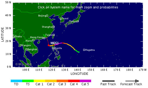
The location and path of Typhoon Megi according to the US Navy forecast.
Typhoon Megi, meaning ' catfish ' in Korean, after devastating the Philippines, this super typhoon began to enter the South China Sea in the west-northwest direction. The US Navy predicted Megi could land in Hong Kong within the next 3 days.
>>>Super storm Megi level up when entering the East Sea
On the afternoon of October 19 , according to the US Navy, Megi was 780km from Hong Kong to the southeast at 2pm (local time) with a wind speed of 185 km and a travel speed of 11km / hour in the west-northwest direction. . The US National Hurricane Center predicts the winds of the storm can reach 213km / hr when it crosses the South China Sea, at level 4 on the Saffir-Simpson Hurricane Scale.
According to the US Navy forecast, Megi could land in Hong Kong within 3 days. This storm will "seriously affect " China's coastal region. The China State Disaster Relief Committee issued a warning to a series of provinces in the southern region of the country.
Since October 15 , the Japan Meteorological Agency has predicted that the storm Megi is forming could land in the northern Philippines within 5 days. According to the agency, Megi could become a strong storm at level 4 under the Saffir-Simpson Hurricane Scale, with the highest level being 5.
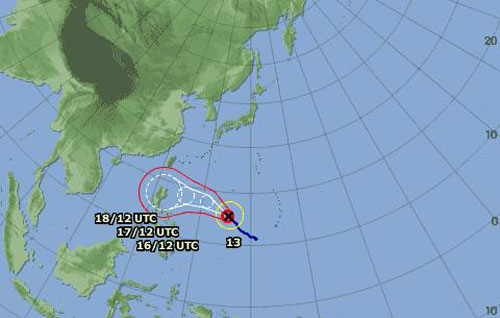
Forecast of storm direction of Japan Meteorological Agency on October 15.
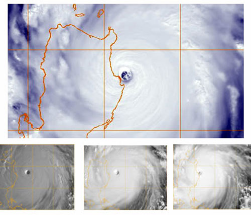
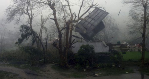
In the afternoon of October 18 , the storm described as the strongest storm poured into the Philippines in the past four years, landed on Luzon Island, north of the Philippines with winds of more than 225 km / hour, shocking 260 km / hour with heavy rain. The storm killed at least 13 people, destroyed many houses, knocked out trees, caused power outages, widespread flooding and damaged the area considered to be the country's food staple with dozens of estimates. million dollars. Coastal cities in central Vietnam have begun to be affected by storms with downpour.
On the evening of October 18 , Megi left the Philippines, the storm weakened as he crossed the mountainous area of Luzon Island. According to the US National Hurricane Center and the Tropical Storm Risk prediction network (http://www.tropicalstormrisk.com/) of the UK, Megi will strengthen when crossing Luzon Island and with wind speeds of more than 250km / hour. It can be a Category 5 storm - the strongest level according to the Saffir-Simpson Hurricane Scale, and can have devastating consequences.
In the afternoon of October 19 , Megi went to the South China Sea after leaving a white area in the northern Philippines. According to Britain's Tropical Storm Risk (TSR) prediction network, Megi could move away from Vietnam, moving to China, moving between Hainan and Hong Kong.
At 8 am October 19, the storm moved west-northwest with a speed of 15km / hour. Although it is still too early to say exactly where Megi will land in this area, the authorities still warn that the central and western regions of China's Guangdong province are the most at risk. storm. Approximately 140,000 people in 15 cities on Hainan Island must be evacuated.
Video: On every km of National Highway 1A in the Central region
[#RelatedNews (10) #]
 Is the magnetic North Pole shift dangerous to humanity?
 Washington legalizes the recycling of human bodies into fertilizer
 Lightning stone - the mysterious guest
 Stunned by the mysterious sunset, strange appearance