Tsunami devastating Indonesian island formed by?
Earthquake vibration, movement along the sea fault, bay structure can contribute to the intense tsunami sweeping Sulawesi Island, Indonesia.
The strong earthquake of 7.5 degrees that caused Indonesia's Sulawesi island to shake at 5:02 pm in the afternoon via local time. The video shot by witnesses revealed a tsunami rising gradually in the bay near Palu, eventually rushing to shore, causing observers to flee hastily, according to National Geographic.
Scientists who were surprised by the tsunami did not immediately appear immediately after the earthquake, leading to conflicts in warning of risks. But experts say that the unique geology of the region may be the cause of unusual developments of the disaster.
The earthquake took place after a series of strong tremors of 6.1 degrees starting around 2pm. The event not only destroyed many houses but also killed and injured people. The ground continued to sway with 27 aftershocks, paving the way for the magnitude 7.5 earthquake with the epicenter at a depth of 9.7 km, according to the US Geological Survey. After that, 31 aftershocks poured in.
Damage from the earthquake so far is nearly 400 casualties. According to reports from Badan Nasional Penanggulangan Bencana (BNPB), Indonesia's natural disaster prevention agency, earthquakes cause widespread power outages, hindering communications, but local authorities are handling the situation. BNPB said Indonesia will deploy its military for disaster recovery.
Tsunamis are often the result of intense movements of large earthquakes in the sea at the tectonic plate boundary. Earthquakes are common in Indonesia, the country on the Fire Ring, the name for the horseshoe plate boundary chain embracing the Pacific basin. Fire Belt is the place where 90% of earthquakes occur in the world. But tsunamis are unexpected effects, rarely accompanied by earthquakes of this type.
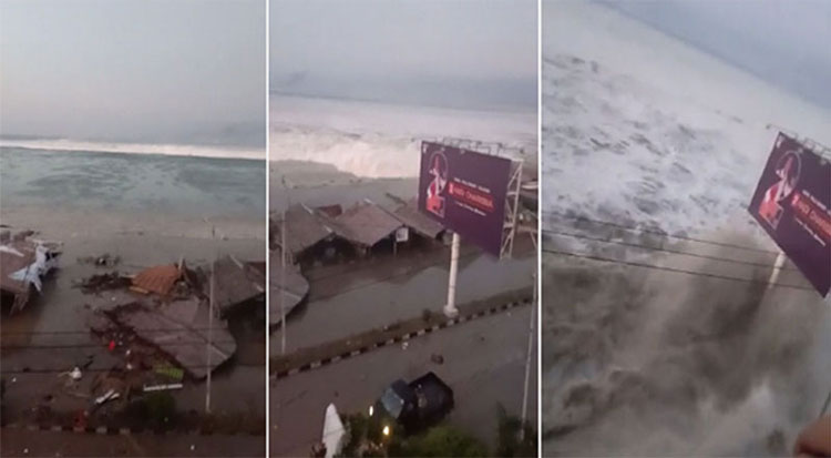
The tsunami rushed to the shore, causing observers to flee hastily.
The 7.5-magnitude earthquake seems to be the result of a horizontal slip fault, which occurs when the two shells crush on each other, mostly in the horizontal direction. Tsunamis often occur after moving along the Earth's crust, breaking the upper layer of water and producing huge waves of energy rushing to the shore.
"This is clearly a surprise," said Baptiste Gombert, a geophysicist at Oxford University. Gombert emphasized Indonesia's geology extremely complex. A network of different types of faults cuts through the area, so determining exactly what happened was a great challenge for scientists.
The tsunami can be generated from movement along the fault, Gombert speculated. But he thinks this is difficult to explain fully about high waves. Some preliminary models estimate tsunamis as high as 5m.'Even if there is only a little disturbance in the vertical, this is still a big tsunami. It is likely that landslides, both by submarines or from shore, also affect the bay water, creating a wave , 'Gombert said.
The boundary of the bay could also contribute to the disaster, according to Janine Krippner, a volcanic house studying at Concord University."The bay structure can amplify the height of the wave when leading water into smaller areas , " Krippner wrote on Twitter.
Indonesian agencies are warning local people to pay attention to possible dangers."It is better not to stay in a house or a high-rise building because of the possibility of a dangerous aftershock. Everyone should gather in a safe area. Stay away from hillsides, mountains" , Sutopo Purwo Nugroho, speaking. BNPB member, said.
- The wilderness scene in Indonesian town was attacked by tsunamis
- The power of Indonesian tsunamis surprised the researchers
- The risk of intense tsunamis in the Pacific
- HOT! The 2-meter tsunami hit Indonesia city after the earthquake
- Strong earthquake, Indonesia warned the tsunami
- The number of people killed by the tsunami in Indonesia is nearly 400
- The previous image - how much later the earthquake made 1200 people die in Indonesia
- Why is the Indonesian tsunami warning not activated?
- The image of Indonesian people disturbing because of the earthquake
- Indonesia again suffered two strong earthquakes
- Close-up of the new island formed on the Red Sea
- Two islands formed by volcanoes form one
 Is the magnetic North Pole shift dangerous to humanity?
 Washington legalizes the recycling of human bodies into fertilizer
 Lightning stone - the mysterious guest
 Stunned by the mysterious sunset, strange appearance