Typhoon Khanun continuously increased its level, moved slowly, and added energy
In the last 6 hours, the number 11 storm has hardly moved.
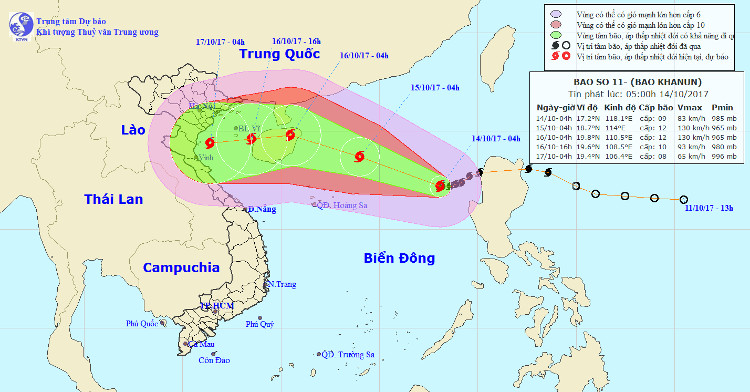
At 04:00 on October 14 , the location of the center of the storm was about 17.2 degrees Vi Bac; 118.1 degrees east longitude, about 660km away from Hoang Sa archipelago to the northeast of the northeast. The strongest wind in the area near the storm center is strong at level 9 (75-90km / hour), level 11 jerks.
It is forecasted that in the next 24 hours, the storm will move west-northwest, every hour is 10-15km and even stronger. At 4 o'clock on October 15, the location of the storm center is about 18.7 degrees Vi Bac; 114.0 degrees Kinh Dong, about 280 km from Hoang Sa archipelago to the Northeast. The strongest wind is in the area near the center of strong storm level 11-12 (100-135km / hour), level 15.

Location and direction of Typhoon Khanun.
Due to the impact of the storm, the North Sea East region has stormy rain; strong wind level 7-9, then increase to level 10-12, level 15 shock. Dangerous zone in the next 24 hours (strong winds of level 6 or higher) from latitude 14.0 to 21.0 degrees North latitude; east of the meridian 111.0 degrees Kinh Dong. Disaster risk level: level 3.
It is forecasted that in the next 24 to 48 hours , the storm will move west and northwest, about 15km per hour. At 04:00 on October 16, the location of the storm center is about 19.8 degrees Vi Bac; 110.5 degrees Kinh Dong, north of Hainan Island (China). The strongest wind in the area near the storm center is strong at level 12 (115-135km / hour), level 15.
It is forecasted that in the next 48 to 72 hours , the storm will move west and northwest, then be able to change the direction of travel in the West every hour to 15-20 km.
Due to the influence of the southwest edge of the circulation of typhoon 11, the middle and south of the South China Sea (including the waters of Truong Sa archipelago), the waters of Binh Thuan to Ca Mau and Ca Mau-Kien Giang have showers and thunderstorms. , in the thunderstorms there is a possibility of wind level 7-8.
- Hurricane number 11 advanced quickly into the South China Sea
- Tin storm on the East Sea: Typhoon Khanun
- The East Sea is about to welcome the 11th storm
- Hurricane number 11 advanced quickly into the South China Sea
- The Storm of the Mountain Is Focusing on Central
- Typhoon Haiyan weakens gradually and goes to China
- Storm No. 4 increased to level 11, entering the Gulf of Tonkin
- The cyclone sank many ships, the Noul storm strengthened to level 16
- Emergency storm (Typhoon Haitang)
- Tin storm on the East Sea: Typhoon Khanun
- Typhoon Khanun weakened into a tropical depression
- Why is the storm No. 6 constantly growing, moving unpredictably?
- Bebinca storms can land in Hai Phong - Nghe An area
- The typhoon Nanmadol indirectly caused the male to rain a lot
- Super Typhoon Wutip level 17 is heading into the Central region
 Is the magnetic North Pole shift dangerous to humanity?
 Washington legalizes the recycling of human bodies into fertilizer
 Lightning stone - the mysterious guest
 Stunned by the mysterious sunset, strange appearance
 Super typhoon Manyi enters the East Sea, cold air moves slowly
  Storm No. 9 Manyi, level 12, about 200km from Hoang Sa archipelago
  Storm Tra Mi enters the East Sea today, strange movement direction
  The Da River fault zone causes earthquakes in Ninh Binh
  Sea levels are rising rapidly due to El Nino and climate change
  Tropical depressions appear into the East Sea, likely to become a typhoon