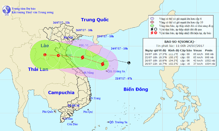
Typhoon Sonca tipped at level 10 toward Thanh Hoa - Quang Binh
At 10 o'clock on July 24, the location of the center of the storm is about 17.3 degrees Vi Bac; 111.1 degrees Kinh Dong, about 160km southeast of Hainan Island (China). The strongest wind is in the area near the center of strong storm level 8 (60-75km / hour), level 9-10.
It is forecasted that in the next 24 hours , the storm will move west and northwest, each hour is 10-15km. At 10 o'clock on July 25, the location of the storm center is about 18.3 degrees Vi Bac; 108.1 degrees east longitude, on the area south of the Tonkin Gulf, about 200km from the mainland of Thanh Hoa-Quang Binh provinces to the east. The strongest wind is in the area near the center of strong storm level 8 (60-75km / hour), level 9-10.
In the next 24 hours , the danger zone (strong winds of level 6 or higher, rough seas) from latitude 16.50N to 20.00N; west of meridian 113.00E. The area near the center of the storm passes through level 8, level 9-10; ocean waves 3-5m high; strong sea.

Location and direction of storm No. 4.
In the next 24 to 48 hours , the storm moved west-northwest, about 15km each hour, went to the mainland from Thanh Hoa to Quang Binh and weakened into a tropical depression. By 10 pm on July 26, the position of the tropical depression center was about 18.6 degrees north latitude; 104.5 degrees east longitude, in central Laos. The strongest wind in the area near the center of strong tropical depression at level 6 (40-50km / hour), shock level 7-8.
From tomorrow morning (July 25) , in the Gulf of Tonkin (including Bach Long Vi island district) with strong winds up to level 6, the area in the South of Tonkin Gulf has strong winds of level 7, the area near the center of the storm passes through 8, shock level 9-10; ocean waves 3-5m high; The waters of the provinces from Thanh Hoa to Quang Binh are high waves of 2-3m. Strong sea.
In the next 48 to 60 hours , tropical depressions move mainly in the west, about 20km every hour, continue to go deep into the mainland and weaken into a low pressure area in Central Laos.
Storm disaster risk level: level 3.
In the afternoon and night today (July 24) , in the provinces from Quang Binh to Quang Ngai there is rain. From July 25, due to the impact of storms, in the provinces from Thanh Hoa to Thua Thien Hue, there is a heavy rain (100-250mm for the whole time). From July 25 evening and night in the Northern Delta, the provinces of Hoa Binh, Son La and the North Central Highlands have moderate rain and heavy rain (50-150mm for the whole period).
In the middle and southern part of the South China Sea (including the waters of the Spratly Islands), the waters from Ninh Thuan to Ca Mau have rainfall and thunderstorms, strong southwest wind level 5, sometimes level 6, level 7-8 shock. , sea waves from 2-3m high, rough seas; Ca Mau to Kien Giang and the Gulf of Thailand have showers and scattered thunderstorms. In a thunderstorm there is a possibility of tornado and a strong wind of level 6-8. Disaster risk level: level 1.
- Typhoon hit Quang Binh - Quang Tri
- This afternoon and evening, the storm No. 4 will land in Ha Tinh - Quang Binh
- Noon 30/8, storm No. 4 went to the mainland from Thanh Hoa to Quang Binh
- Storm No. 10 entered Thanh Hoa-Quang Binh, the strongest in many years
- The Storm of the Mountain Is Focusing on Central
- Weather 26/7: Both countries have rain, flash flood warning and landslides
- The cyclone sank many ships, the Noul storm strengthened to level 16
- This afternoon, Typhoon Nesat landed in Quang Ninh - Nam Dinh
- Tonight the storm landed Hai Phong, Thai Binh and Quang Ninh
- Thousands of houses were destroyed by typhoon level 12
- Typhoon is about to land in Thai Binh - Thanh Hoa
- No.1 storm suddenly changed direction, can go through Hai Phong, Hanoi
 Is the magnetic North Pole shift dangerous to humanity?
 Washington legalizes the recycling of human bodies into fertilizer
 Lightning stone - the mysterious guest
 Stunned by the mysterious sunset, strange appearance