Typhoon Utor is likely to cause heavy rain for the North
At 4 o'clock on August 13, the location of the center of the storm was about 18.2 degrees Vi Bac; 116.1 degrees east longitude. About 450km from Hoang Sa archipelago to the East Northeast. The strongest wind in the area near the center of the storm is level 13 (ie from 134 to 149km per hour), jerking level 15, level 16.
It is forecasted that in the next 24 hours, the storm will move in the direction of West and Northwest Northwest, about 15 - 20km per hour and there is also a strong possibility. At 04:00 on August 14, the location of the storm center is about 20.0 degrees north latitude; 112.0 Kinh Dong, about 110km from Hainan Island (China) to the East. The strongest wind in the area near the storm center is strong at level 14 (ie from 150 to 166km per hour), level 16, level 17.
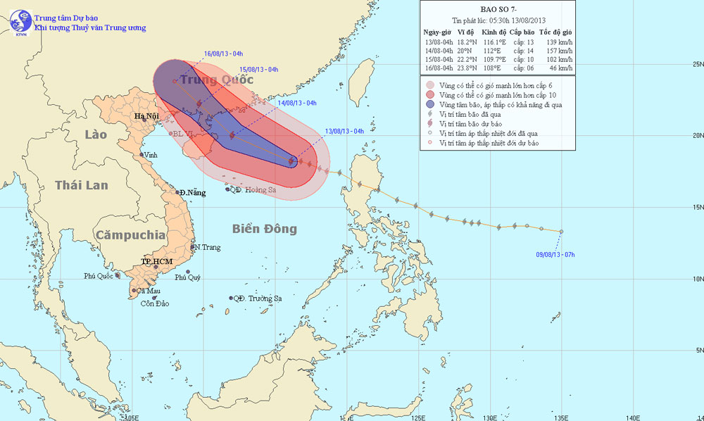
Photo of the path and location of Typhoon Utor
In the next 24 to 48 hours, the storm is capable of changing the direction of travel in the Northwest direction, about 15km per hour. At 04:00 on August 15, the location of the storm center is about 22.2 degrees Vi Bac; 109.7 degrees Kinh Dong, on the mainland southeast of Guangxi province (China). The strongest wind in the area near the center of the storm is strong at level 10 (ie from 89 to 102 km per hour), tugging at level 11 level 12.
In the next 48 to 72 hours, the storm continued to move in the Northwest direction, about 10km per hour.
Due to the impact of storms, in the North Sea, the North Sea has strong winds of level 11, level 12, the area near the center of the storm passes through level 13, level 14, level 16, level 17. The sea is fierce. The north-eastern waters of the Hoang Sa archipelago have strong winds that rise to level 8, level 9, then increase to level 10, level 11, shock level 12, level 13. The sea is fierce.
In addition, due to the strong influence of the southwest monsoon, the area between the South and the South China Sea (including the Spratlys waters), the waters from Binh Thuan to Ca Mau have strong winds of level 6, shock level 7 , level 8 and showers and strong thunderstorms. The sea is rough. In a thunderstorm, there should be a tornado.
- Super hurricane Utor into China
- Utor storm will cause heavy rain in the northeast provinces
- Utor storm tomorrow causes strong winds of 100km / h in the Gulf of Tonkin
- Typhoon No. 4 weakened, the North and the North Central region had heavy heavy rain
- Son Tinh storms weakened into low pressure, North Trung Bo was heavy rain
- Floods raged across China, 105 people died
- Typhoon Wipha will cause heavy rain in the North
- Typhoon Utor crossed Luzon Island, into the South China Sea
- Storm No. 3 will land directly from Quang Ninh to Nam Dinh, Bac Bo with heavy rain
- Large-scale heavy rains in the North will likely last until July 22
- The North urgently resisted Typhoon Haiyan
- In the North, there is still a large area of rain, the Central Vietnam has ended the heat
 Is the magnetic North Pole shift dangerous to humanity?
 Washington legalizes the recycling of human bodies into fertilizer
 Lightning stone - the mysterious guest
 Stunned by the mysterious sunset, strange appearance