Bailu stormed against the East Sea, Ha Tinh - Quang Tri with heavy rain
This morning, August 23, typhoon Bailu is about 330km from Luzon Island, Philippines, level 12 whirlwind wind. Today and night, provinces from Thanh Hoa to Thua Thien Hue have moderate rain and heavy rain.
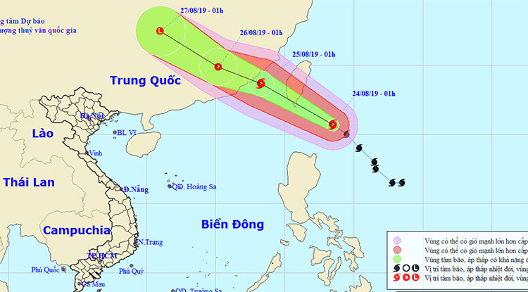
According to the National Center for Meteorological and Hydrological Forecasting, at 1 am August 24, Bailu storm center is operating near the South China Sea about 330km northeast of Luzon Island, Philippines. The strongest wind in the area near the storm center is strong at level 10 (90-100km / h), level 12 jerks.

Bailu storm forecast diagram is operating near the East Sea - (Photo: National Center for Meteorological and Hydrological Forecasting)
It is forecasted that in the next 24 hours , the storm will move in the Northwest direction, about 20km per hour and there is a strong possibility. At 1:00 on August 25 , the storm center right on the waters of Fujian Province - Guangdong (China). The strongest wind in the area near the storm center is strong at level 11 (100-115km / h), level 13 is jerky.
In the next 24-48 hours , the storm moved mainly in the direction of West-Northwest, about 15-20km per hour, going into the mainland of Fujian-Guangdong provinces and then weakening into tropical depression.
At 1:00 on August 26, tropical depression on mainland Southeast China. The strongest wind in the area near the strong tropical low pressure center level 7 (50-60km / h), level 9 shock.
In the next 48-72 hours , tropical depressions moved west-northwest, about 20 km per hour, going deep into the mainland China and weakening into a low pressure area.
On the mainland, due to the influence of low pressure grooves combined with the convergence of wind from 1,500m-5,000m, the days and nights of the provinces from Thanh Hoa to Thua Thien Hue have moderate rain, rain (popular rainfall). 30-60mm / 24h), particularly in Ha Tinh, Quang Binh and Quang Tri provinces with very heavy rain (popular rainfall 70-120mm / 24h).
The forecast of heavy rain in North and Central Central is likely to last until August 25. In thunderstorms there is the possibility of whirlwinds, lightning, hail and strong winds.
The Central Highlands and the South of Vietnam on August 24 have showers and thunderstorms in some places, particularly in the evening there are showers and scattered with thunderstorms, in case of tornado, lightning and wind gusts.
- Tin storm near the East Sea: Typhoon Bailu, North and North Central thunderstorms
- Tin storm near the East Sea: Typhoon Bailu, North and North Central thunderstorms
- The Storm of the Mountain Is Focusing on Central
- Depression in Ha Tinh-Quang Binh, causing heavy rain
- Son Tinh storm level up, entering the East Sea
- Sơn Tinh became the No. 8 storm in the South China Sea
- Son Tinh storm is about to enter the East Sea
- Low pressure to become a storm, landed in Ha Tinh - Quang Binh
- The South China Sea is about to be stormed, warning of heavy rain
- Tom Tinh storms tomorrow night into Central Vietnam
- Son Tinh storm swept through the Philippines, 6 people died
- Many Quang Binh people eat white rice, shrimp noodles live on the roof
- Flooding in the roof of Quang Binh
 Is the magnetic North Pole shift dangerous to humanity?
 Washington legalizes the recycling of human bodies into fertilizer
 Lightning stone - the mysterious guest
 Stunned by the mysterious sunset, strange appearance