Son Tinh storm is about to enter the East Sea
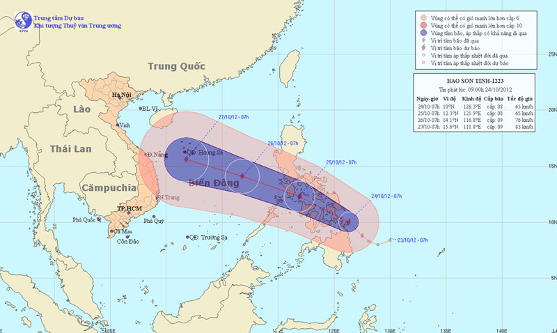
At 13:00 on October 24, the location of Son Tinh's storm center is about 10.4 degrees Vi Bac; 125.3 degrees Kinh Dong, on the northern area of Min Da Nao Island (Philippines). The strongest winds in the area near the storm center are strong at level 8 (ie 62 to 74 km per hour), level 9 and level 10 jerks.
It is forecasted that in the next 24 hours, the storm will move in the West Northwest direction, about 20 - 25 km per hour. By 13:00 on October 25, the location of the center of the storm was about 13.1 degrees north latitude; 119.6 degrees east longitude, about 900km from Hoang Sa archipelago to the southeast. The strongest wind in the area near the storm center is strong at level 8 (ie 62 to 74km per hour), level 9 and level 10 jerks.

The path and location of the storm
In the next 24 to 48 hours, the storm moves mainly in the West-Northwest direction, every hour is about 20-25 km and has a stronger ability. At 13 o'clock on October 26, the location of the center of the storm was about 15.0 degrees north latitude; 114.3 degrees Kinh Dong, about 310 km from Hoang Sa archipelago to the southeast. The strongest winds in the area near the storm center are strong at level 8, level 9 (ie 62 to 88 km per hour), level 10 and level 11 jerks.
In the next 48 to 72 hours, move in the direction between West and West Northwest, about 20 - 25km per hour.
Due to the influence of storm circulation, from tomorrow morning (October 25) in the East Sea the East Sea will gradually increase to level 6, level 7, the area near the center of the storm passes through level 8, level 9, level 10 jerks, level 11. The sea is very strong.
- Sơn Tinh became the No. 8 storm in the South China Sea
- Son Tinh storm level up, entering the East Sea
- Son Tinh storm swept through the Philippines, 6 people died
- Storm No. 8 weakens into a tropical depression
- Storm No. 10 approached the land of Ha Tinh - Quang Binh
- Hurricane No. 3 moves quickly, landing in provinces from Thai Binh to Ha Tinh
- The Storm of the Mountain Is Focusing on Central
- Tom Tinh storms tomorrow night into Central Vietnam
- Podul storm into the East Sea, the wind 60-75km / h
- Typhoon Kalmaegi entered the South China Sea, possibly landing in Quang Ninh - Hai Phong
- Storm swept over 3 hours in Nghe An - Ha Tinh
- Noon, the 7th storm will enter the East Sea
 Is the magnetic North Pole shift dangerous to humanity?
 Washington legalizes the recycling of human bodies into fertilizer
 Lightning stone - the mysterious guest
 Stunned by the mysterious sunset, strange appearance
 Super typhoon Manyi enters the East Sea, cold air moves slowly
  Storm No. 9 Manyi, level 12, about 200km from Hoang Sa archipelago
  Storm Tra Mi enters the East Sea today, strange movement direction
  The Da River fault zone causes earthquakes in Ninh Binh
  Sea levels are rising rapidly due to El Nino and climate change
  Tropical depressions appear into the East Sea, likely to become a typhoon