Storm receding away from the mainland, the development is very complicated
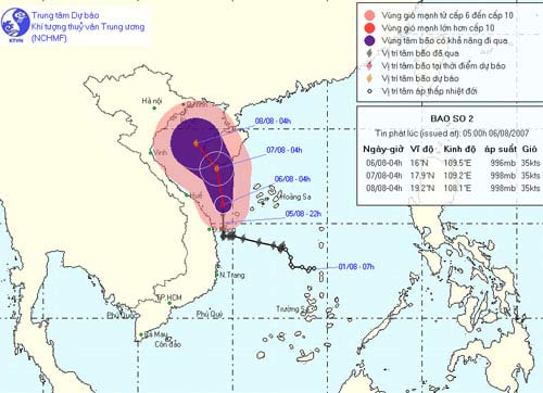
At 4am on August 6, the position of the center of the storm No. 2 is about 16.0 degrees north latitude; 109.5 degrees east longitude, on the waters of Quang Nam - Thua Thien Hue, about 100 km east of Da Nang coast. The strongest wind is in the area near the center of strong storm level 8 (ie from 62 to 74 km per hour), jerking at level 8.
It is forecasted that in the next 24 hours, the typhoon 2 will move in the direction of north and north northwest, about 10km per hour. At 4 o'clock on August 7, the location of the center of the storm is about 17.9 degrees north latitude; 109.2 degrees east longitude, about 60 km south of Hainan Island (China). Dangerous strong wind radius from level 6 up from the center of storm about 100km.
Due to the impact of storms, offshore waters from Da Nang to Quang Tri and the southern part of the Gulf of Bac Bo have strong winds of level 6, level 7, the area near the center of storm level 8, shocking on level 8. Strong sea level.
In the next 24 to 48 hours, storm No. 2 moves north-northwest, about 10 km per hour. At 4 o'clock on August 8, the location of the storm center is about 19.2 degrees north latitude; 108.1 degrees east longitude, about 110 km south of Bach Long Vi island. Dangerous strong wind radius from level 6 up from the center of storm about 100km.
In the next few days, the provinces from Da Nang to Thanh Hoa, the North East and the Central Highlands have moderate rain, heavy rain, and a place with very heavy rain. Need to prevent flash floods and landslides.
In addition, due to strong influence with strong southwest monsoon winds, the waters from Binh Thuan to Ca Mau and the South China Sea region have strong winds of level 7, level 8, level 9. The sea is strong. In the thunderstorm in case there is a strong whirlwind.
Storm No. 2 is still complicated.
- Storm No. 1 enters the mainland and weakens into a low pressure
- Storm Dianmu accelerated, Hanoi prepared to catch a storm
- Typhoon 4 advanced quickly to the mainland
- Typhoon Sarika will land in Vietnam
- This morning, the storm started to cause rain in the Central region
- Strong tropical depression into storm No. 1, approaching the Vietnamese mainland
- Storm No. 7 is complicated, causing widespread rain
- Storm No. 6 is approaching the Vietnam-China border, the North is about to rain very hard
- Storm No. 3 is about 180km from Quang Ninh - Hai Phong
- Storm No. 13 could change direction, targeting Central
- The storm with extraordinary speed is heading into the South China Sea
- Why is it difficult to predict storms?
 Is the magnetic North Pole shift dangerous to humanity?
 Washington legalizes the recycling of human bodies into fertilizer
 Lightning stone - the mysterious guest
 Stunned by the mysterious sunset, strange appearance